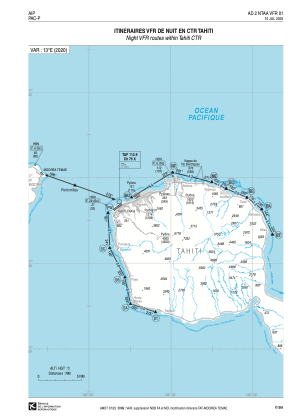
VAC chart of NTAA
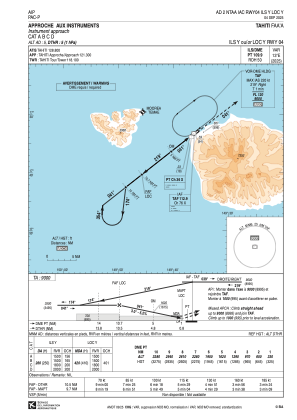
 IAC chart of NTAA
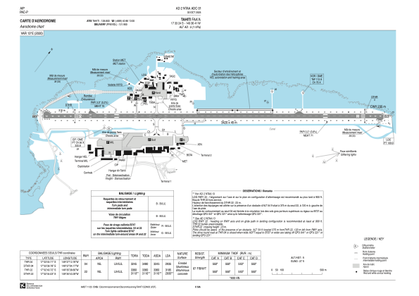
 ADC chart of NTAA
 Satellite view of NTAA
IAC chart of NTAAADC chart of NTAA
Satellite view of NTAA
Sorry, we have no imagery here.
Sorry, we have no imagery here.
Sorry, we have no imagery here.
Sorry, we have no imagery here.
Sorry, we have no imagery here.


NTAA - Tahiti Faa'a
Located in Papeete (Polynesie Francaise), French Polynesia
ICAO - NTAA, IATA - PPT
Data provided by AirmateGeneral information
Coordinates: S17°33'24" W149°36'41"
Elevation is 5 feet MSL.
Magnetic variation is 12.94° East View others Airports in (unassigned)
Operational data
Special qualification required
Current time UTC:
Current local time:
Weather
METAR: NTAA 192100Z AUTO 06014KT 9999 SCT058 BKN070 30/23 Q1013 BECMG FEW023TCU SCT070 BKN200
TAF: TAF NTAA 191700Z 1918/2024 VRB03KT 9999 FEW023TCU SCT070 BKN200 TEMPO 1920/2003 05014KT PROB40 TEMPO 2000/2003 05015G25KT 3000 SHRA FEW017TCU SCT020 SCT045
Communications frequencies: [VIEW]
Runways:
| RWY identifier | QFU | Length (ft) | Width (ft) | Surface | LDA (ft) |
| 04 | 54° | 11220 | 148 | BITUM | 9629 |
| 22 | 234° | 11220 | 148 | BITUM | 10449 |
Airport contact information
Address: Papeete (Polynesie Francaise) French Polynesia


Satellite view of NTAA
Sorry, we have no imagery here.
Sorry, we have no imagery here.
Sorry, we have no imagery here.
Sorry, we have no imagery here.
Sorry, we have no imagery here.