ADC chart of N69
 Satellite view of N69
Satellite view of N69
Sorry, we have no imagery here.
Sorry, we have no imagery here.
Sorry, we have no imagery here.
Sorry, we have no imagery here.
Sorry, we have no imagery here.
Sorry, we have no imagery here.


N69 - Stormville
Located in Stormville, United States
ICAO - N69, IATA -
Data provided by AirmateGeneral information
Coordinates: N41°34'37" W73°43'56"
Elevation is 358 feet MSL.
Magnetic variation is -12° East View others Airports in New York
Operational data
Special qualification required
Current time UTC:
Current local time:
Weather at : KPOU - Hudson Valley Rgnl ( 14 km )
METAR: KPOU 251953Z 18008G16KT 10SM CLR 26/09 A3006 RMK AO2 SLP175 T02610089
TAF: KPOU 251739Z 2518/2618 22009G15KT P6SM BKN120 FM260600 17007G15KT P6SM -SHRA OVC050 TEMPO 2607/2610 4SM -RA OVC025 FM261000 17007KT 3SM -RA OVC020 FM261500 22010G18KT 6SM -SHRA OVC025
Communications frequencies: [VIEW]
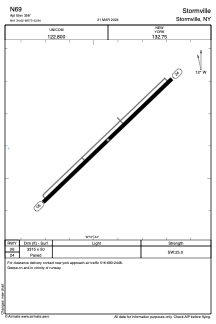
Runways:
| RWY identifier | QFU | Length (ft) | Width (ft) | Surface | LDA (ft) |
| 06 | 46° | 3315 | 50 | ASPH | |
| 24 | 226° | 3315 | 50 | ASPH |
Airport contact information
Address: Stormville United States
Satellite view of N69
Sorry, we have no imagery here.
Sorry, we have no imagery here.
Sorry, we have no imagery here.
Sorry, we have no imagery here.
Sorry, we have no imagery here.
Sorry, we have no imagery here.