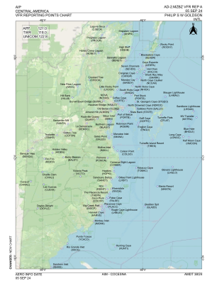
VAC chart of MZBZ
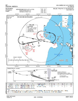
 IAC chart of MZBZ
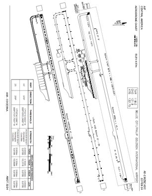
 ADC chart of MZBZ
 Satellite view of MZBZ
IAC chart of MZBZADC chart of MZBZ
Satellite view of MZBZ
Sorry, we have no imagery here.
Sorry, we have no imagery here.
Sorry, we have no imagery here.
Sorry, we have no imagery here.
Sorry, we have no imagery here.


MZBZ - Belize City / Philip S W Goldson Intl
Located in Belize City, Belize
ICAO - MZBZ, IATA - BZE
Data provided by AirmateGeneral information
Coordinates: N17°32'21" W88°18'30"
Elevation is 15 feet MSL.
View others Airports in Belize District
Operational data
Special qualification required
Current time UTC:
Current local time:
Weather
METAR: MZBZ 211800Z 11009KT 9999 SCT028 33/24 A2987 Q1011 NOSIG
TAF: TAF MZBZ 211605 2118/2218 10008KT 9999 SCT025
Communications frequencies: [VIEW]
Runways:
| RWY identifier | QFU | Length (ft) | Width (ft) | Surface | LDA (ft) |
| 07 | 77° | 9678 | 148 | ASP | |
| 25 | 257° | 9678 | 148 | ASP |
Airport contact information
Address: Belize City Belize
Satellite view of MZBZ
Sorry, we have no imagery here.
Sorry, we have no imagery here.
Sorry, we have no imagery here.
Sorry, we have no imagery here.
Sorry, we have no imagery here.