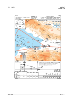
IAC chart of MTPP
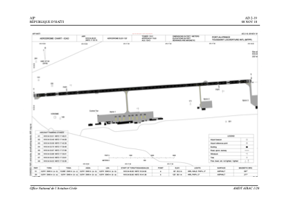
 ADC chart of MTPP
 Satellite view of MTPP
ADC chart of MTPP
Satellite view of MTPP
Sorry, we have no imagery here.
Sorry, we have no imagery here.
Sorry, we have no imagery here.
Sorry, we have no imagery here.
Sorry, we have no imagery here.
Sorry, we have no imagery here.


MTPP - Port-Au-Prince/International
Located in Port Au Prince, Haiti
ICAO - MTPP, IATA - PAP
Data provided by AirmateGeneral information
Coordinates: N18°34'48" W72°17'33"
Elevation is 122 feet MSL.
View others Airports in Ouest Department
Operational data
Special qualification required
Current time UTC:
Current local time:
Weather
TAF: TAF MTPP 181700Z 1818/1918 08007KT 9999 FEW026CB FM181800 29011KT 9000 SCT024CB PROB30 TEMPO 1900/1905 09008KT 4900 TSRA SCT014CB SCT040 FM190600 10010KT 7000 FEW018
Communications frequencies: [VIEW]
Runways:
| RWY identifier | QFU | Length (ft) | Width (ft) | Surface | LDA (ft) |
| 10 | 87° | 10039 | 148 | ASP | |
| 28 | 267° | 10039 | 148 | ASP |
Airport contact information
Address: Port Au Prince Haiti
Satellite view of MTPP
Sorry, we have no imagery here.
Sorry, we have no imagery here.
Sorry, we have no imagery here.
Sorry, we have no imagery here.
Sorry, we have no imagery here.
Sorry, we have no imagery here.