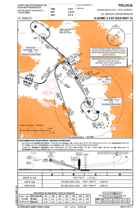
IAC chart of MMTO
 ADC chart of MMTO
 Satellite view of MMTO
ADC chart of MMTO
Satellite view of MMTO
Sorry, we have no imagery here.
Sorry, we have no imagery here.
Sorry, we have no imagery here.
Sorry, we have no imagery here.
Sorry, we have no imagery here.
Sorry, we have no imagery here.


MMTO - Toluca Aeropuerto Internacional Lic. Adolfo Lopez Mateos
Located in Toluca, Mexico
ICAO - MMTO, IATA - TLC
Data provided by AirmateGeneral information
Coordinates: N19°20'14" W99°33'58"
Elevation is 8466 feet MSL.
View others Airports in Mexico
Operational data
Special qualification required
Current time UTC:
Current local time:
Weather
METAR: MMTO 222249Z 09003KT 8SM SCT020 BKN200 21/00 A3029 RMK 8/508 HZY
TAF: TAF MMTO 222236Z 2300/2400 13015KT 6SM TS BKN020CB BKN080 OVC200 TX21/2320Z TN09/2312Z TEMPO 2300/2303 5SM TSRA FM230700 00000KT 5SM HZ SCT020 SCT200 TEMPO 2310/2314 2SM BR HZ FM231500 14005KT 5SM HZ SCT020 BECMG 2320/2321 23010KT P6SM SCT020 TEMPO 2321/2324 5SM TSRA BKN020CB
Communications frequencies: [VIEW]
Runways:
| RWY identifier | QFU | Length (ft) | Width (ft) | Surface | LDA (ft) |
| 15 | 157° | 13780 | 148 | ASP | |
| 33 | 337° | 13780 | 148 | ASP |
Airport contact information
Address: Toluca Mexico
Satellite view of MMTO
Sorry, we have no imagery here.
Sorry, we have no imagery here.
Sorry, we have no imagery here.
Sorry, we have no imagery here.
Sorry, we have no imagery here.
Sorry, we have no imagery here.