VAC chart of MMSD
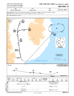
 IAC chart of MMSD
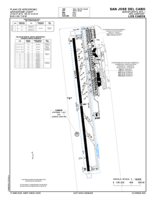
 ADC chart of MMSD
 Satellite view of MMSD
IAC chart of MMSDADC chart of MMSD
Satellite view of MMSD
Sorry, we have no imagery here.
Sorry, we have no imagery here.
Sorry, we have no imagery here.
Sorry, we have no imagery here.
Sorry, we have no imagery here.
Sorry, we have no imagery here.


MMSD - San Jose Del Cabo Aeropuerto Internacional Los Cabos
Located in San Jose Del Cabo, Mexico
ICAO - MMSD, IATA - SJD
Data provided by AirmateGeneral information
Coordinates: N23°9'7" W109°43'15"
Elevation is 381 feet MSL.
View others Airports in Baja California Sur
Operational data
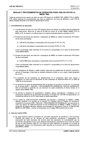
Special qualification required
Current time UTC:
Current local time:
Weather
METAR: MMSD 252245Z 13012KT 10SM SCT250 27/13 A2988 RMK 8/008
TAF: TAF MMSD 251647Z 2518/2618 14015KT P6SM SKC FM260300 34005KT P6SM SKC
Communications frequencies: [VIEW]
Runways:
| RWY identifier | QFU | Length (ft) | Width (ft) | Surface | LDA (ft) |
| 16 | 173° | 9856 | 148 | ASP | |
| 34 | 353° | 9856 | 148 | ASP |
Airport contact information
Address: San Jose Del Cabo Mexico
Satellite view of MMSD
Sorry, we have no imagery here.
Sorry, we have no imagery here.
Sorry, we have no imagery here.
Sorry, we have no imagery here.
Sorry, we have no imagery here.
Sorry, we have no imagery here.