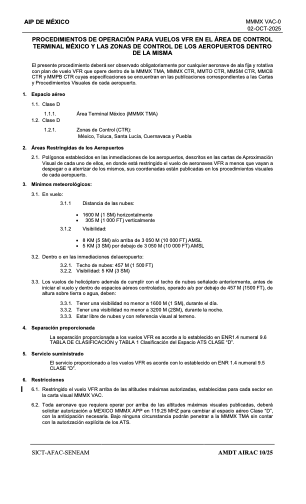
VAC chart of MMMX
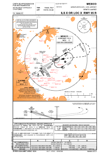
 IAC chart of MMMX
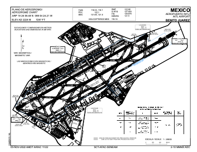
 ADC chart of MMMX
 Satellite view of MMMX
IAC chart of MMMXADC chart of MMMX
Satellite view of MMMX
Sorry, we have no imagery here.
Sorry, we have no imagery here.
Sorry, we have no imagery here.
Sorry, we have no imagery here.
Sorry, we have no imagery here.


MMMX - Mexico Aeropuerto Internacional Benito Juarez
Located in Mexico, Mexico
ICAO - MMMX, IATA - MEX
Data provided by AirmateGeneral information
Coordinates: N19°26'9" W99°4'24"
Elevation is 7297 feet MSL.
View others Airports in Distrito Federal
Operational data
Special qualification required
Current time UTC:
Current local time:
Weather
TAF: TAF MMMX 021735Z 0218/0318 16010KT P6SM SCT220 TX31/0221Z TN12/0312Z TEMPO 0222/0302 16008G18KT FM030300 15004KT P6SM SCT220 FM031600 13006KT P6SM SKC
Communications frequencies: [VIEW]
Runways:
| RWY identifier | QFU | Length (ft) | Width (ft) | Surface | LDA (ft) |
| 05L | 59° | 12861 | 148 | ASP | |
| 23R | 239° | 12861 | 148 | ASP | |
| 05R | 59° | 13432 | 148 | ASP | |
| 23L | 239° | 13432 | 148 | ASP |
Airport contact information
Address: Mexico Mexico
Satellite view of MMMX
Sorry, we have no imagery here.
Sorry, we have no imagery here.
Sorry, we have no imagery here.
Sorry, we have no imagery here.
Sorry, we have no imagery here.