VAC chart of MMMX
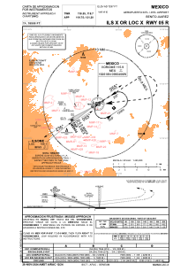
 IAC chart of MMMX
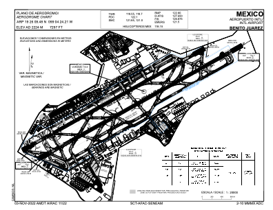
 ADC chart of MMMX
 Satellite view of MMMX
IAC chart of MMMXADC chart of MMMX
Satellite view of MMMX
Sorry, we have no imagery here.
Sorry, we have no imagery here.
Sorry, we have no imagery here.
Sorry, we have no imagery here.
Sorry, we have no imagery here.


MMMX - Mexico Aeropuerto Internacional Benito Juarez
Located in Mexico, Mexico
ICAO - MMMX, IATA - MEX
Data provided by AirmateGeneral information
Coordinates: N19°26'9" W99°4'24"
Elevation is 7297 feet MSL.
View others Airports in Distrito Federal
Operational data
Special qualification required
Current time UTC:
Current local time:
Weather
METAR: MMMX 191350Z 06004KT 7SM SKC 19/10 A3027 NOSIG RMK HZY ISOL CI
TAF: TAF MMMX 191111Z 1912/2012 06005KT P6SM SCT220 TX30/1920Z TN13/1912Z FM191800 14010KT P6SM SCT020 BECMG 1921/1922 BKN020CB TEMPO 1922/2002 4SM TSRA FM200300 03005KT P6SM SCT080 SCT200 BECMG 2005/2006 00000KT SCT200
Communications frequencies: [VIEW]
Runways:
| RWY identifier | QFU | Length (ft) | Width (ft) | Surface | LDA (ft) |
| 05L | 59° | 12861 | 148 | ASP | |
| 23R | 239° | 12861 | 148 | ASP | |
| 05R | 59° | 13432 | 148 | ASP | |
| 23L | 239° | 13432 | 148 | ASP |
Airport contact information
Address: Mexico Mexico
Satellite view of MMMX
Sorry, we have no imagery here.
Sorry, we have no imagery here.
Sorry, we have no imagery here.
Sorry, we have no imagery here.
Sorry, we have no imagery here.