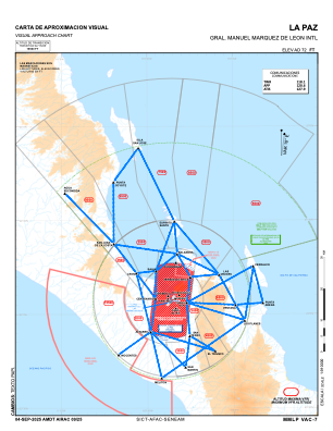
VAC chart of MMLP
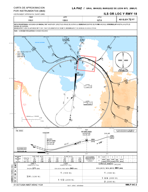
 IAC chart of MMLP
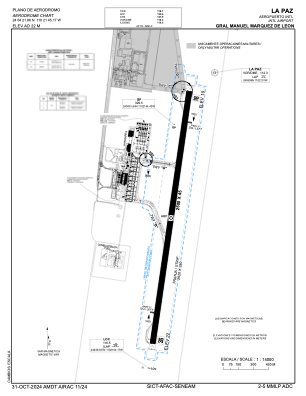
 ADC chart of MMLP
 Satellite view of MMLP
IAC chart of MMLPADC chart of MMLP
Satellite view of MMLP
Sorry, we have no imagery here.
Sorry, we have no imagery here.
Sorry, we have no imagery here.
Sorry, we have no imagery here.
Sorry, we have no imagery here.
Sorry, we have no imagery here.


MMLP - La Paz Aeropuerto Internacional Gral. Manuel Marquez De Leon
Located in La Paz, Mexico
ICAO - MMLP, IATA - LAP
Data provided by AirmateGeneral information
Coordinates: N24°4'22" W110°21'45"
Elevation is 69 feet MSL.
View others Airports in Baja California Sur
Operational data
Special qualification required
Current time UTC:
Current local time:
Weather
METAR: MMLP 180042Z 35008KT 10SM SCT200 35/06 A2987 RMK 8/008
TAF: TAF MMLP 171645Z 1718/1818 34012KT P6SM BKN200 FM180300 20010KT P6SM BKN250
Communications frequencies: [VIEW]
Runways:
| RWY identifier | QFU | Length (ft) | Width (ft) | Surface | LDA (ft) |
| 18 | 188° | 8202 | 148 | CON | |
| 36 | 8° | 8202 | 148 | CON |
Airport contact information
Address: La Paz Mexico
Satellite view of MMLP
Sorry, we have no imagery here.
Sorry, we have no imagery here.
Sorry, we have no imagery here.
Sorry, we have no imagery here.
Sorry, we have no imagery here.
Sorry, we have no imagery here.