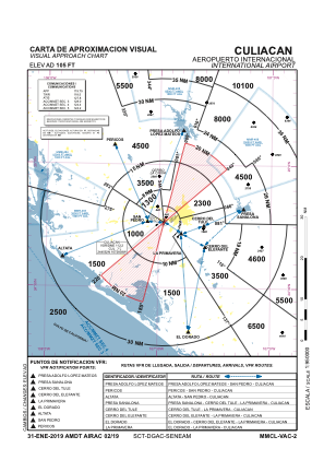
VAC chart of MMCL
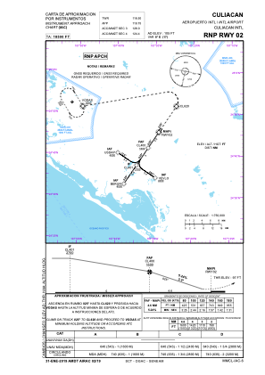
 IAC chart of MMCL
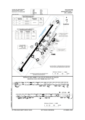
 ADC chart of MMCL
 Satellite view of MMCL
IAC chart of MMCLADC chart of MMCL
Satellite view of MMCL
Sorry, we have no imagery here.
Sorry, we have no imagery here.
Sorry, we have no imagery here.
Sorry, we have no imagery here.
Sorry, we have no imagery here.
Sorry, we have no imagery here.


MMCL - Culiacan Sin. Aeropuerto Internacional
Located in Culiacan, Mexico
ICAO - MMCL, IATA - CUL
Data provided by AirmateGeneral information
Coordinates: N24°45'54" W107°28'31"
Elevation is 108 feet MSL.
View others Airports in Sinaloa
Operational data
Special qualification required
Current time UTC:
Current local time:
Weather
METAR: MMCL 180450Z 14003KT 10SM SKC 27/15 A2986 RMK HZY
TAF: TAF MMCL 180503Z 1806/1906 00000KT P6SM SCT200 FM181900 25015KT P6SM BKN200 BECMG 1902/1904 00000KT SCT200
Communications frequencies: [VIEW]
Runways:
| RWY identifier | QFU | Length (ft) | Width (ft) | Surface | LDA (ft) |
| 03 | 33° | 7139 | 148 | UNK | |
| 21 | 213° | 7139 | 148 | UNK |
Airport contact information
Address: Culiacan Mexico
Satellite view of MMCL
Sorry, we have no imagery here.
Sorry, we have no imagery here.
Sorry, we have no imagery here.
Sorry, we have no imagery here.
Sorry, we have no imagery here.
Sorry, we have no imagery here.