IAC chart of MHPR
ADC chart of MHPR
Satellite view of MHPR
Sorry, we have no imagery here.
To navigate, press the arrow keys.
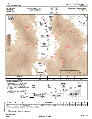
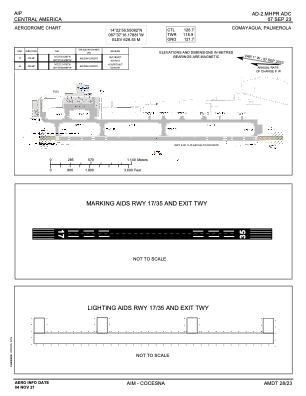
MHPR - Palmerola International
Located in Comayagua, Honduras
ICAO - , IATA - XPL
Data provided by
Airmate
General information
Coordinates:
N14°22'57" W87°37'16"
Elevation is
2064 feet MSL.
Add your vote
Valid your vote
View others
Airports in
Comayagua
Operational data
Special qualification required
Current time UTC:
Current local time:
Weather at :
MHTG - Toncontin
( 56 km )
METAR:
MHTG 312100Z 30003KT 9999 BKN032 FEW034TCU 30/16 Q1015 A2997 NOSIG
TAF:
TAF MHTG 311700Z 3118/0118 19010KT 9999 SCT034TCU TX33/3121Z TN19/0112Z BECMG 0104/0106 VRB04KT 7000 RA FEW028TCU BKN030 BECMG 0109/0111 9999 NSW FEW010 SCT026
View NOTAMs / SUP AIP / TFR affecting this airport
[VIEW]
Communications frequencies:
[VIEW]
Runways:
RWY identifier
QFU
Length
(ft)
Width
(ft)
Surface
LDA
(ft)
17
170°
8009
148
UNK
35
350°
8009
148
UNK
Airport contact information
Address:
Comayagua Honduras
Satellite view of MHPR
Sorry, we have no imagery here.
To navigate, press the arrow keys.
<<
BESbswy
BESbswy