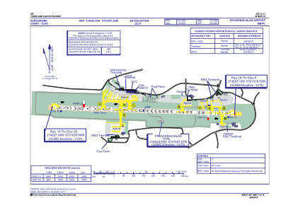
ADC chart of MBPV
 Satellite view of MBPV
Satellite view of MBPV
Sorry, we have no imagery here.
Sorry, we have no imagery here.
Sorry, we have no imagery here.
Sorry, we have no imagery here.
Sorry, we have no imagery here.


MBPV - Providenciales International
Located in Providenciales, Turks and Caicos Islands
ICAO - MBPV, IATA - PLS
Data provided by AirmateGeneral information
Coordinates: N21°46'26" W72°16'7"
Elevation is 28 feet MSL.
Magnetic variation is -10° East View others Airports in Providenciales
Operational data
Special qualification required
Current time UTC:
Current local time:
Weather
METAR: MBPV 170000Z 09007KT 9999 SCT015CB 30/23 Q1014
TAF: TAF MBPV 162305Z 1700/1724 07004KT 9999 SCT020 BECMG 1712/1714 10008KT
Communications frequencies: [VIEW]
Runways:
| RWY identifier | QFU | Length (ft) | Width (ft) | Surface | LDA (ft) |
| 10 | 93° | 9199 | 148 | ASP | |
| 28 | 273° | 9199 | 148 | ASP |
Airport contact information
Address: Providenciales Turks and Caicos Islands
Satellite view of MBPV
Sorry, we have no imagery here.
Sorry, we have no imagery here.
Sorry, we have no imagery here.
Sorry, we have no imagery here.
Sorry, we have no imagery here.