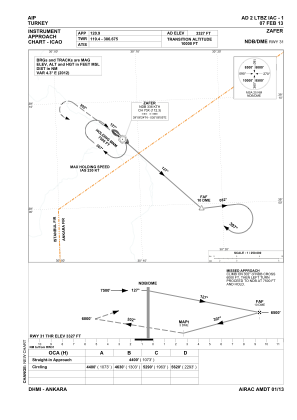
IAC chart of LTBZ
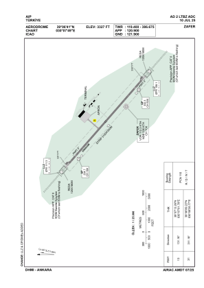
 ADC chart of LTBZ
 Satellite view of LTBZ
ADC chart of LTBZ
Satellite view of LTBZ
Sorry, we have no imagery here.
Sorry, we have no imagery here.
Sorry, we have no imagery here.
Sorry, we have no imagery here.
Sorry, we have no imagery here.
Sorry, we have no imagery here.


LTBZ - Zafer
Located in Kutahya, Turkey
ICAO - LTBZ, IATA - KZR
Data provided by AirmateGeneral information
Coordinates: N39°6'41" E30°7'49"
Elevation is 3327 feet MSL.
Magnetic variation is 5.2° East View others Airports in Manisa
Operational data
Special qualification required
Current time UTC:
Current local time:
Weather
TAF: TAF LTBZ 270140Z 2703/2712 VRB02KT CAVOK
Communications frequencies: [VIEW]
Runways:
| RWY identifier | QFU | Length (ft) | Width (ft) | Surface | LDA (ft) |
| 13 | 131° | 9843 | 148 | CONC | 9843 |
| 31 | 311° | 9843 | 148 | CONC | 9843 |
Airport contact information
Address: Kutahya Turkey
Satellite view of LTBZ
Sorry, we have no imagery here.
Sorry, we have no imagery here.
Sorry, we have no imagery here.
Sorry, we have no imagery here.
Sorry, we have no imagery here.
Sorry, we have no imagery here.