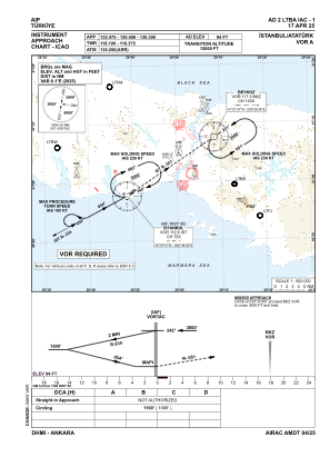
IAC chart of LTBA
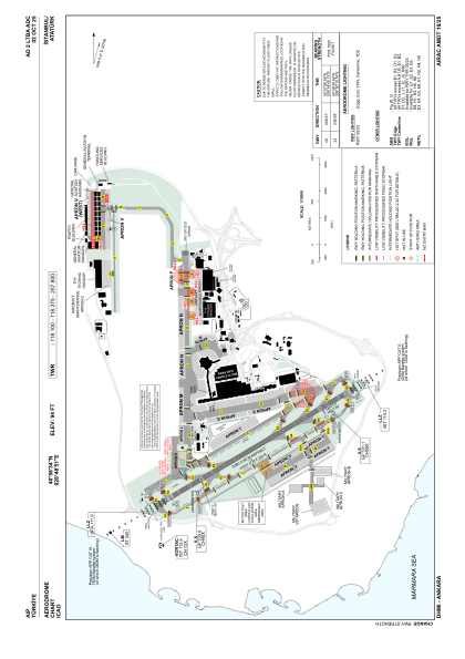
 ADC chart of LTBA
 Satellite view of LTBA
ADC chart of LTBA
Satellite view of LTBA
Sorry, we have no imagery here.
Sorry, we have no imagery here.
Sorry, we have no imagery here.
Sorry, we have no imagery here.
Sorry, we have no imagery here.
Sorry, we have no imagery here.


LTBA - Istanbul Ataturk
Located in Istanbul, Turkey
ICAO - LTBA, IATA - ISL
Data provided by AirmateGeneral information
Coordinates: N40°58'34" E28°48'51"
Elevation is 94 feet MSL.
Magnetic variation is 5.4° East View others Airports in Istanbul
Operational data
Special qualification required
Current time UTC:
Current local time:
Weather at : LTFM - Istanbul ( 34 km )
METAR: LTFM 091820Z 15005KT CAVOK 08/M05 Q1020 NOSIG RMK RWY17L 09006KT RWY34L VRB04KT RWY16R 09004KT 050V110 RWY36 11004KT 030V140 RWY18 09004KT 060V120
TAF: TAF LTFM 091640Z 0918/1024 05007KT CAVOK BECMG 0918/0921 21010KT BECMG 1006/1009 22018G28KT SCT035 BKN100 TEMPO 1011/1015 -SHRA BKN025 BKN080 TEMPO 1017/1021 -SHRA FEW018CB BKN025 BECMG 1018/1021 34020G30KT PROB30 TEMPO 1021/1024 -TSRA FEW018CB BKN022
Communications frequencies: [VIEW]
Runways:
| RWY identifier | QFU | Length (ft) | Width (ft) | Surface | LDA (ft) |
| 05 | 59° | 8465 | 197 | ASPH | 8038 |
| 23 | 239° | 8465 | 197 | ASPH | 8465 |
Airport contact information
Address: Istanbul Turkey
Satellite view of LTBA
Sorry, we have no imagery here.
Sorry, we have no imagery here.
Sorry, we have no imagery here.
Sorry, we have no imagery here.
Sorry, we have no imagery here.
Sorry, we have no imagery here.