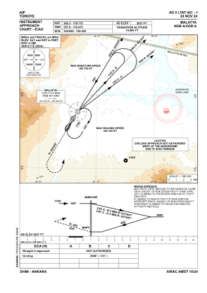
IAC chart of LTAT
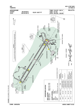
 ADC chart of LTAT
 Satellite view of LTAT
ADC chart of LTAT
Satellite view of LTAT
Sorry, we have no imagery here.
Sorry, we have no imagery here.
Sorry, we have no imagery here.
Sorry, we have no imagery here.
Sorry, we have no imagery here.
Sorry, we have no imagery here.


LTAT - Malatya
Located in Malatya, Turkey
ICAO - LTAT, IATA - MLX
Data provided by AirmateGeneral information
Coordinates: N38°25'56" E38°4'59"
Elevation is 2837 feet MSL.
Magnetic variation is 5.6° East View others Airports in Malatya
Operational data
Special qualification required
Current time UTC:
Current local time:
Weather
TAF: TAF LTAT 301040Z 3012/3112 29008KT 6000 -SHRA SCT006 BKN030 OVC090 TEMPO 3013/3017 3500 BR BECMG 3020/3021 SCT040 BKN100 TEMPO 3108/3112 23012KT
Communications frequencies: [VIEW]
Runways:
| RWY identifier | QFU | Length (ft) | Width (ft) | Surface | LDA (ft) |
| 03L | 32° | 10991 | 148 | CONC+ASPH | 10991 |
| 21R | 212° | 10991 | 148 | CONC+ASPH | 10991 |
| 03R | 32° | 10991 | 148 | ASPH | 10991 |
| 21L | 212° | 10991 | 148 | ASPH | 10991 |
Airport contact information
Address: Malatya Turkey
Satellite view of LTAT
Sorry, we have no imagery here.
Sorry, we have no imagery here.
Sorry, we have no imagery here.
Sorry, we have no imagery here.
Sorry, we have no imagery here.
Sorry, we have no imagery here.