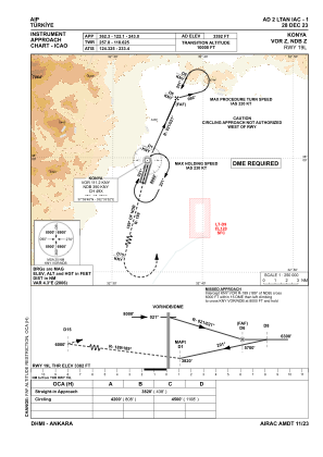
IAC chart of LTAN
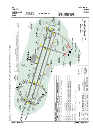
 ADC chart of LTAN
 Satellite view of LTAN
ADC chart of LTAN
Satellite view of LTAN
Sorry, we have no imagery here.
Sorry, we have no imagery here.
Sorry, we have no imagery here.
Sorry, we have no imagery here.
Sorry, we have no imagery here.
Sorry, we have no imagery here.


LTAN - Konya
Located in Konya, Turkey
ICAO - LTAN, IATA - KYA
Data provided by AirmateGeneral information
Coordinates: N37°58'50" E32°33'45"
Elevation is 3392 feet MSL.
Magnetic variation is 5.3° East View others Airports in Konya
Operational data
Special qualification required
Current time UTC:
Current local time:
Weather
METAR: LTAN 091650Z VRB02KT 9999 FEW040 SCT100 12/M03 Q1013 NOSIG
TAF: TAF LTAN 091640Z 0918/1003 VRB02KT 9999 FEW040 SCT100 BECMG 0919/0921 CAVOK
Communications frequencies: [VIEW]
Runways:
| RWY identifier | QFU | Length (ft) | Width (ft) | Surface | LDA (ft) |
| 01R | 17° | 10984 | 148 | CONC | 10984 |
| 19L | 197° | 10984 | 148 | CONC | 10984 |
| 01L | 17° | 10984 | 148 | CONC+ASPH | 10984 |
| 19R | 197° | 10984 | 148 | CONC+ASPH | 10984 |
Airport contact information
Address: Konya Turkey
Satellite view of LTAN
Sorry, we have no imagery here.
Sorry, we have no imagery here.
Sorry, we have no imagery here.
Sorry, we have no imagery here.
Sorry, we have no imagery here.
Sorry, we have no imagery here.