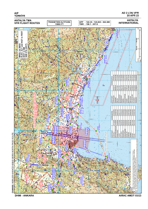
VAC chart of LTAI
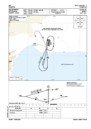
 IAC chart of LTAI
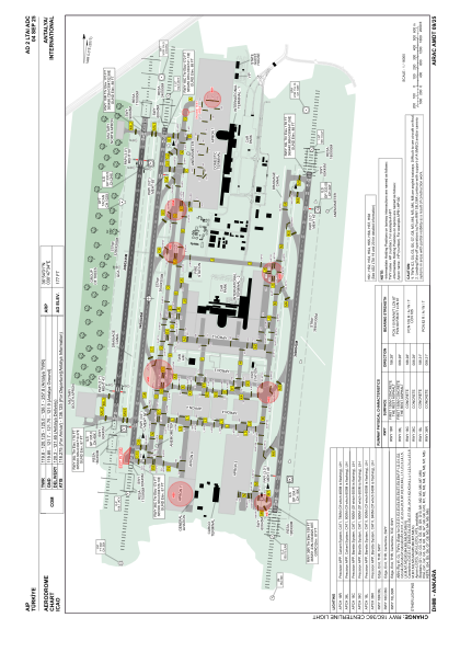
 ADC chart of LTAI
 Satellite view of LTAI
IAC chart of LTAIADC chart of LTAI
Satellite view of LTAI
Sorry, we have no imagery here.
Sorry, we have no imagery here.
Sorry, we have no imagery here.
Sorry, we have no imagery here.
Sorry, we have no imagery here.
Sorry, we have no imagery here.


LTAI - Antalya
Located in Antalya, Turkey
ICAO - LTAI, IATA - AYT
Data provided by AirmateGeneral information
Coordinates: N36°54'1" E30°47'34"
Elevation is 177 feet MSL.
Magnetic variation is 5.0° East View others Airports in Antalya
Operational data
Special qualification required
Current time UTC:
Current local time:
Weather
METAR: LTAI 091150Z 10014KT 9999 -TSRA FEW015CB BKN025 17/09 Q1009 BECMG TL1250 NSW RMK RWY18C 09008KT 060V130 RWY36R 09012KT 050V120 RWY18L 09010KT 070V130
TAF: TAF LTAI 091040Z 0912/1012 15009KT 9999 FEW015CB BKN025 TEMPO 0912/0916 -TSRA FEW015CB BKN025 BECMG 0916/0919 34015G25KT SCT030 BECMG 0921/0924 CAVOK
Communications frequencies: [VIEW]
Runways:
| RWY identifier | QFU | Length (ft) | Width (ft) | Surface | LDA (ft) |
| 18R | 186° | 9810 | 148 | ASPH | 9810 |
| 36L | 6° | 9810 | 148 | ASPH | 9810 |
| 18L | 186° | 11155 | 148 | CONC | 11155 |
| 36R | 6° | 11155 | 148 | CONC | 11155 |
| 18C | 186° | 11155 | 148 | CONC | 11155 |
| 36C | 6° | 11155 | 148 | CONC | 11155 |
Airport contact information
Address: Antalya Turkey
Satellite view of LTAI
Sorry, we have no imagery here.
Sorry, we have no imagery here.
Sorry, we have no imagery here.
Sorry, we have no imagery here.
Sorry, we have no imagery here.
Sorry, we have no imagery here.