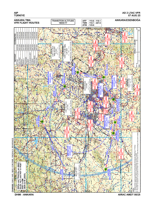
VAC chart of LTAC
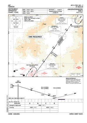
 IAC chart of LTAC
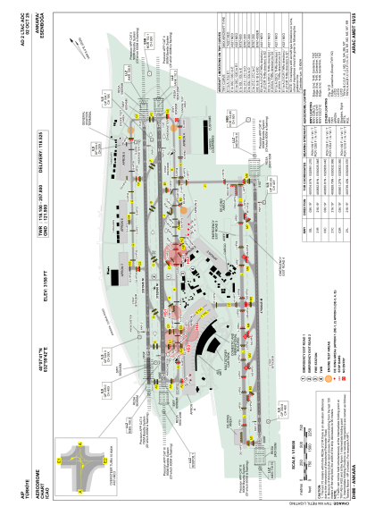
 ADC chart of LTAC
 Satellite view of LTAC
IAC chart of LTACADC chart of LTAC
Satellite view of LTAC
Sorry, we have no imagery here.
Sorry, we have no imagery here.
Sorry, we have no imagery here.
Sorry, we have no imagery here.
Sorry, we have no imagery here.
Sorry, we have no imagery here.


LTAC - Ankara Esenboga
Located in Ankara, Turkey
ICAO - LTAC, IATA - ESB
Data provided by AirmateGeneral information
Coordinates: N40°7'41" E32°59'42"
Elevation is 3127 feet MSL.
Magnetic variation is 5.6° East View others Airports in Ankara
Operational data
Special qualification required
Current time UTC:
Current local time:
Weather
METAR: LTAC 292050Z 06005KT 020V090 CAVOK 11/01 Q1007 NOSIG RMK RWY21L VRB02KT RWY03L 07006KT RWY21R VRB03KT
TAF: TAF LTAC 291640Z 2918/3018 27012KT 9999 SCT040 SCT200 BECMG 2918/2921 VRB02KT CAVOK BECMG 3003/3006 23012KT SCT040 SCT100 PROB30 3012/3016 -TSRA FEW025CB BKN030
Communications frequencies: [VIEW]
Runways:
| RWY identifier | QFU | Length (ft) | Width (ft) | Surface | LDA (ft) |
| 03L | 36° | 11125 | 148 | ASPH | 11125 |
| 21R | 216° | 11125 | 148 | ASPH | 11125 |
| 03R | 36° | 12310 | 197 | ASPH | 12310 |
| 21L | 216° | 12310 | 197 | ASPH | 12310 |
Airport contact information
Address: Ankara Turkey
Satellite view of LTAC
Sorry, we have no imagery here.
Sorry, we have no imagery here.
Sorry, we have no imagery here.
Sorry, we have no imagery here.
Sorry, we have no imagery here.
Sorry, we have no imagery here.