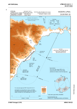
VAC chart of LPMA
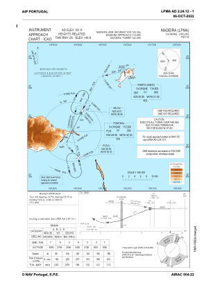
 IAC chart of LPMA
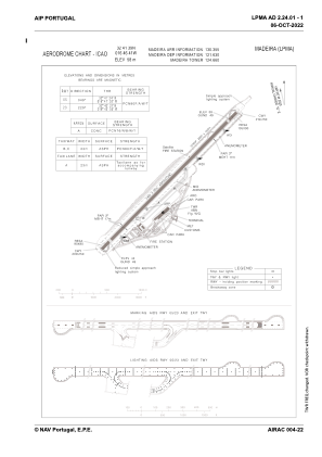
 ADC chart of LPMA
 Satellite view of LPMA
IAC chart of LPMAADC chart of LPMA
Satellite view of LPMA
Sorry, we have no imagery here.
Sorry, we have no imagery here.
Sorry, we have no imagery here.
Sorry, we have no imagery here.
Sorry, we have no imagery here.
Sorry, we have no imagery here.


LPMA - Madeira
Located in Funchal, Portugal
ICAO - LPMA, IATA - FNC
Data provided by AirmateGeneral information
Coordinates: N32°41'39" W16°46'41"
Elevation is 190 feet MSL.
Magnetic variation is -004.4678° East View others Airports in Autonomous Region of Madeira
Operational data
Special qualification required
Current time UTC:
Current local time:
Weather
METAR: LPMA 180330Z 34010KT 290V010 9999 FEW016 18/08 Q1016
TAF: TAF LPMA 172300Z 1800/1824 35013KT 9999 SCT015 BECMG 1800/1802 33007KT TEMPO 1800/1808 BKN014 BECMG 1804/1806 VRB05KT PROB30 TEMPO 1810/1818 20010KT
Communications frequencies: [VIEW]
Runways:
| RWY identifier | QFU | Length (ft) | Width (ft) | Surface | LDA (ft) |
| 05 | 45° | 9124 | 148 | ASP | |
| 23 | 225° | 9124 | 148 | ASP |
Airport contact information
Address: Funchal Portugal

Satellite view of LPMA
Sorry, we have no imagery here.
Sorry, we have no imagery here.
Sorry, we have no imagery here.
Sorry, we have no imagery here.
Sorry, we have no imagery here.
Sorry, we have no imagery here.