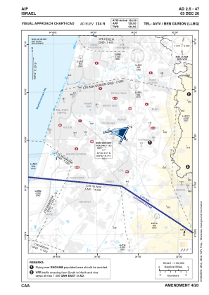
VAC chart of LLBG
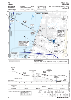
 IAC chart of LLBG
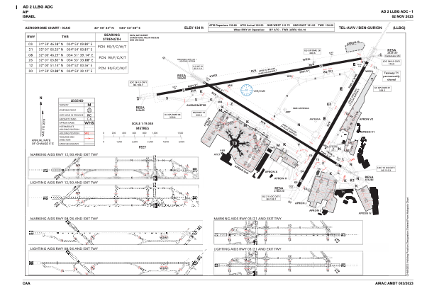
 ADC chart of LLBG
 Satellite view of LLBG
IAC chart of LLBGADC chart of LLBG
Satellite view of LLBG
Sorry, we have no imagery here.
Sorry, we have no imagery here.
Sorry, we have no imagery here.
Sorry, we have no imagery here.
Sorry, we have no imagery here.
Sorry, we have no imagery here.


LLBG - Tel-Aviv/Ben-Gurion
Located in Tel Aviv, Israel
ICAO - LLBG, IATA - TLV
Data provided by AirmateGeneral information
Coordinates: N32°0'34" E34°53'8"
Elevation is 134 feet MSL.
Magnetic variation is 5° East View others Airports in Center District
Operational data
Special qualification required
Current time UTC:
Current local time:
Weather
METAR: LLBG 290650Z 30007KT 9999 SCT030 BKN037 19/12 Q1012 NOSIG
TAF: TAF LLBG 290503Z 2906/3006 28010KT 9999 SCT025 TEMPO 2906/2907 VRB04KT BKN020 BECMG 2907/2909 30012KT SCT030 BECMG 2915/2917 VRB03KT PROB40 TEMPO 2922/3004 BKN025 TX22/2911Z TN13/3003Z
Communications frequencies: [VIEW]
Runways:
| RWY identifier | QFU | Length (ft) | Width (ft) | Surface | LDA (ft) |
| 03 | 29° | 9094 | 197 | ASPH | 9094 |
| 21 | 209° | 9094 | 197 | ASPH | 9094 |
| 08 | 80° | 13327 | 148 | ASPH | 11745 |
| 26 | 260° | 13327 | 148 | ASPH | 11358 |
| 12 | 121° | 10210 | 148 | ASPH | 10210 |
| 30 | 301° | 10210 | 148 | ASPH | 9948 |
Airport contact information
Address: Tel Aviv Israel
Satellite view of LLBG
Sorry, we have no imagery here.
Sorry, we have no imagery here.
Sorry, we have no imagery here.
Sorry, we have no imagery here.
Sorry, we have no imagery here.
Sorry, we have no imagery here.