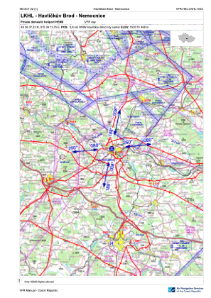
VAC chart of LKHL
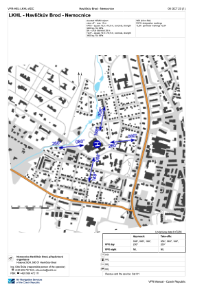
 ADC chart of LKHL
 Satellite view of LKHL

ADC chart of LKHL
Satellite view of LKHL
Sorry, we have no imagery here.
Sorry, we have no imagery here.
Sorry, we have no imagery here.
Sorry, we have no imagery here.
Sorry, we have no imagery here.
Sorry, we have no imagery here.


LKHL - Havlickuv Brod - Nemocnice
Located in Havlickuv Brod, Czech Republic
ICAO - , IATA -
Data provided by AirmateGeneral information
Coordinates: N49°36'37" E15°34'14"
Elevation is 1535 feet MSL.
View others Airports in Vysocina Region
Operational data
Special qualification required
Current time UTC:
Current local time:
Weather at : LKCV - Caslav ( 39 km )
TAF: TAF LKCV 172300Z 1800/1900 VRB02KT CAVOK
Communications frequencies: [VIEW]
Runways:
Airport contact information
Address: Havlickuv Brod Czech Republic
Satellite view of LKHL
Sorry, we have no imagery here.
Sorry, we have no imagery here.
Sorry, we have no imagery here.
Sorry, we have no imagery here.
Sorry, we have no imagery here.
Sorry, we have no imagery here.