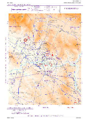
VAC chart of LIRQ
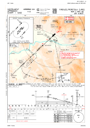
 IAC chart of LIRQ
 ADC chart of LIRQ
 Satellite view of LIRQ
IAC chart of LIRQADC chart of LIRQ
Satellite view of LIRQ
Sorry, we have no imagery here.
Sorry, we have no imagery here.
Sorry, we have no imagery here.
Sorry, we have no imagery here.
Sorry, we have no imagery here.
Sorry, we have no imagery here.


LIRQ - Firenze/Peretola
Located in Firenze, Italy
ICAO - LIRQ, IATA - FLR
Data provided by AirmateGeneral information
Coordinates: N43°48'31" E11°12'10"
Elevation is 142 feet MSL.
View others Airports in Tuscany
Operational data
Special qualification required
Current time UTC:
Current local time:
Weather
METAR: LIRQ 291250Z 05010KT 360V080 9999 SCT040 SCT080 16/07 Q1002
TAF: TAF LIRQ 291100Z 2912/3012 03010KT 9999 BKN040 TEMPO 2912/2918 SHRA
Communications frequencies: [VIEW]
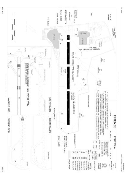
Runways:
| RWY identifier | QFU | Length (ft) | Width (ft) | Surface | LDA (ft) |
| 05 | 48° | 5118 | 148 | ASP | |
| 23 | 228° | 5118 | 148 | ASP |
Airport contact information
Address: Firenze Italy
Satellite view of LIRQ
Sorry, we have no imagery here.
Sorry, we have no imagery here.
Sorry, we have no imagery here.
Sorry, we have no imagery here.
Sorry, we have no imagery here.
Sorry, we have no imagery here.