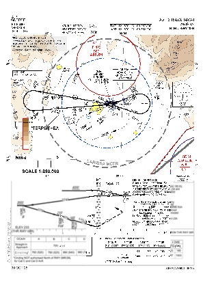
VAC chart of LGLR
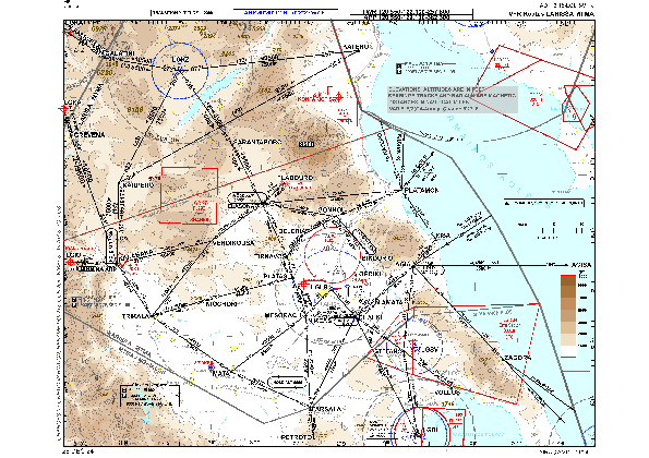 IAC chart of LGLR
 Satellite view of LGLR
IAC chart of LGLR
Satellite view of LGLR
Sorry, we have no imagery here.
Sorry, we have no imagery here.
Sorry, we have no imagery here.
Sorry, we have no imagery here.
Sorry, we have no imagery here.
Sorry, we have no imagery here.


LGLR - Larissa
Located in Larissa, Greece
ICAO - LGLR, IATA - LRA
Data provided by AirmateGeneral information
Coordinates: N39°39'1" E22°27'55"
Elevation is 243 feet MSL.
View others Airports in Larissa
Operational data
Special qualification required
Current time UTC:
Current local time:
Weather
TAF: TAF LGLR 170200Z 1703/1712 VRB03KT 9000 SCT020 PROB40 1703/1705 4000 BR SCT018 PROB30 1703/1705 0800 FG BKN008
Communications frequencies: [VIEW]
Runways:
| RWY identifier | QFU | Length (ft) | Width (ft) | Surface | LDA (ft) |
| 08R | 79° | 11832 | 98 | ASP | |
| 26L | 259° | 11832 | 98 | ASP | |
| 08C | 0° | 11939 | 148 | UNK | |
| 26C | 0° | 11939 | 148 | UNK |
Airport contact information
Address: Larissa Greece
Satellite view of LGLR
Sorry, we have no imagery here.
Sorry, we have no imagery here.
Sorry, we have no imagery here.
Sorry, we have no imagery here.
Sorry, we have no imagery here.
Sorry, we have no imagery here.