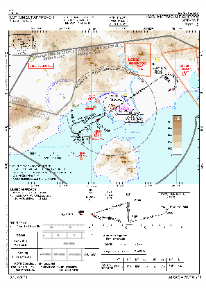
VAC chart of LGKV
 IAC chart of LGKV
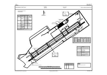
 ADC chart of LGKV
 Satellite view of LGKV

IAC chart of LGKVADC chart of LGKV
Satellite view of LGKV
Sorry, we have no imagery here.
Sorry, we have no imagery here.
Sorry, we have no imagery here.
Sorry, we have no imagery here.
Sorry, we have no imagery here.
Sorry, we have no imagery here.


LGKV - Kavala / Megas Alexandros
Located in Kavala, Greece
ICAO - LGKV, IATA - KVA
Data provided by AirmateGeneral information
Coordinates: N40°54'50" E24°37'11"
Elevation is 17 feet MSL.
View others Airports in Kavala
Operational data
Special qualification required
Current time UTC:
Current local time:
Communications frequencies: [VIEW]
Runways:
| RWY identifier | QFU | Length (ft) | Width (ft) | Surface | LDA (ft) |
| 05 | 55° | 9843 | 148 | UNK | |
| 23 | 235° | 9843 | 148 | UNK |
Airport contact information
Address: Kavala Greece
Handlers

Other aviation service providers
Flight schools

Satellite view of LGKV
Sorry, we have no imagery here.
Sorry, we have no imagery here.
Sorry, we have no imagery here.
Sorry, we have no imagery here.
Sorry, we have no imagery here.
Sorry, we have no imagery here.