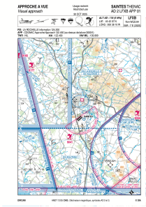
VAC chart of LFXB
 Satellite view of LFXB

Satellite view of LFXB
Sorry, we have no imagery here.
Sorry, we have no imagery here.
Sorry, we have no imagery here.
Sorry, we have no imagery here.
Sorry, we have no imagery here.


LFXB - Saintes Thenac
Located in Saintes, France
ICAO - LFXB, IATA - XST
Data provided by AirmateGeneral information
Coordinates: N45°42'7" W0°38'10"
Elevation is 118 feet MSL.
Magnetic variation is 0.31° East View others Airports in Poitou-Charentes
Operational data
Special qualification required
Current time UTC:
Current local time:
Weather at : LFBG - Cognac Chateaubernard ( 25 km )
METAR: LFBG 191330Z AUTO 14012KT CAVOK 20/08 Q1018 TEMPO 14015G25KT
TAF: TAF LFBG 190800Z 1909/2009 14012KT CAVOK TEMPO 1912/1915 14015G25KT
Communications frequencies: [VIEW]
Runways:
| RWY identifier | QFU | Length (ft) | Width (ft) | Surface | LDA (ft) |
| 05L | 52° | 2953 | 262 | GRASS | |
| 23R | 232° | 2953 | 262 | GRASS | |
| 05R | 52° | 2953 | 164 | GRASS | |
| 23L | 232° | 2953 | 164 | GRASS | |
| 12 | 120° | 2625 | 328 | GRASS | |
| 30 | 300° | 2625 | 328 | GRASS | |
| 05 | 52° | 3609 | 148 | ASPH | 3281 |
| 23 | 232° | 3609 | 148 | ASPH | 3281 |
Airport contact information
Address: Saintes France
Fuel provider

Other aviation service providers
Aviation club (not for profit)

Aviation medical examiner

Satellite view of LFXB
Sorry, we have no imagery here.
Sorry, we have no imagery here.
Sorry, we have no imagery here.
Sorry, we have no imagery here.
Sorry, we have no imagery here.