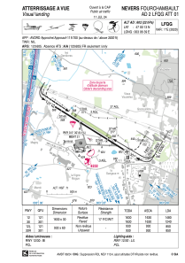
VAC chart of LFQG
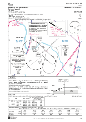
 IAC chart of LFQG
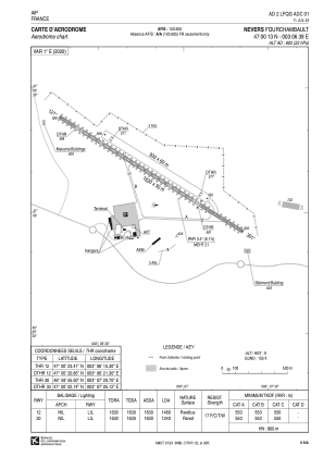
 ADC chart of LFQG
 Satellite view of LFQG

IAC chart of LFQGADC chart of LFQG
Satellite view of LFQG
Sorry, we have no imagery here.
Sorry, we have no imagery here.
Sorry, we have no imagery here.
Sorry, we have no imagery here.
Sorry, we have no imagery here.
Sorry, we have no imagery here.


LFQG - Nevers Fourchambault
Located in Nevers, France
ICAO - LFQG, IATA - NVS
Data provided by AirmateGeneral information
Coordinates: N47°0'13" E3°6'39"
Elevation is 602 feet MSL.
Magnetic variation is 1.33° East View others Airports in Burgundy
Operational data
Special qualification required
Current time UTC:
Current local time:
Communications frequencies: [VIEW]
Runways:
| RWY identifier | QFU | Length (ft) | Width (ft) | Surface | LDA (ft) |
| 12L | 122° | 3051 | 197 | GRASS | 2789 |
| 30R | 302° | 3051 | 197 | GRASS | 2789 |
| 12 | 122° | 5348 | 98 | ASPH | 4856 |
| 30 | 302° | 5348 | 98 | ASPH | 4068 |
Airport contact information
Address: Nevers France
Other aviation service providers
Aviation club (not for profit)

Satellite view of LFQG
Sorry, we have no imagery here.
Sorry, we have no imagery here.
Sorry, we have no imagery here.
Sorry, we have no imagery here.
Sorry, we have no imagery here.
Sorry, we have no imagery here.