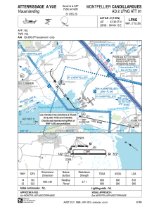
VAC chart of LFNG
 Satellite view of LFNG

Satellite view of LFNG
Sorry, we have no imagery here.
Sorry, we have no imagery here.
Sorry, we have no imagery here.
Sorry, we have no imagery here.
Sorry, we have no imagery here.
Sorry, we have no imagery here.


LFNG - Montpellier Candillargues
Located in Montpellier, France
ICAO - LFNG, IATA -
Data provided by AirmateGeneral information
Coordinates: N43°36'37" E4°4'13"
Elevation is 5 feet MSL.
Magnetic variation is 1.6530° East View others Airports in Languedoc-Roussillon
Operational data
Special qualification required
Current time UTC:
Current local time:
Weather at : LFMT - Montpellier Mediterranee ( 9 km )
METAR: LFMT 200030Z AUTO 34006KT 9999 OVC047 09/07 Q1028 TEMPO BKN020 FEW030CB OVC050
Communications frequencies: [VIEW]
Runways:
| RWY identifier | QFU | Length (ft) | Width (ft) | Surface | LDA (ft) |
| 14 | 144° | 2953 | 98 | ASPH | 2657 |
| 32 | 324° | 2953 | 98 | ASPH | 2953 |
Airport contact information
Address: Montpellier France
Fuel provider

Other aviation service providers
Aviation club (not for profit)

Satellite view of LFNG
Sorry, we have no imagery here.
Sorry, we have no imagery here.
Sorry, we have no imagery here.
Sorry, we have no imagery here.
Sorry, we have no imagery here.
Sorry, we have no imagery here.