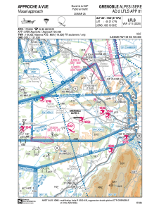
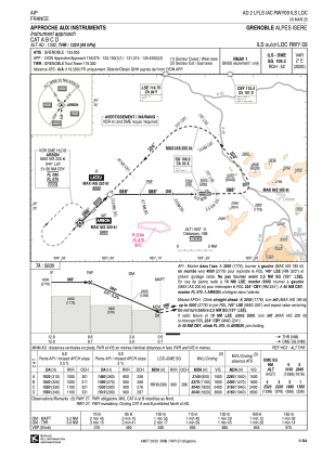
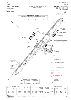


LFLS - Grenoble Alpes Isere
Located in Grenoble, France
ICAO - LFLS, IATA - GNB
Data provided by AirmateGeneral information
Coordinates: N45°21'47" E5°19'58"
Elevation is 1302 feet MSL.
Magnetic variation is 1.95° East View others Airports in Rhône Alpes
Operational data
Special qualification required
Current time UTC:
Current local time:
Weather
METAR: LFLS 260030Z AUTO VRB03KT 9999 FEW050 14/11 Q1021
TAF: TAF LFLS 251400Z 2515/2615 35010KT 9999 BKN036 PROB40 TEMPO 2603/2609 26003KT 3000 BR BKN009
Communications frequencies: [VIEW]
Runways:
| RWY identifier | QFU | Length (ft) | Width (ft) | Surface | LDA (ft) |
| 09R | 90° | 2953 | 164 | GRASS | |
| 27L | 270° | 2953 | 164 | GRASS | |
| 09 | 90° | 10007 | 148 | ASPH | 10007 |
| 27 | 270° | 10007 | 148 | ASPH | 10007 |
Airport contact information
Address: Grenoble France

