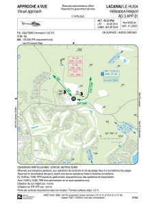
VAC chart of LFH116
 Satellite view of LFH116

Satellite view of LFH116
Sorry, we have no imagery here.
Sorry, we have no imagery here.
Sorry, we have no imagery here.
Sorry, we have no imagery here.
Sorry, we have no imagery here.


LFH116 - Lacanau Le Huga
Located in , France
ICAO - , IATA -
Data provided by AirmateGeneral information
Coordinates: N45°0'25" W1°9'53"
Elevation is 52 feet MSL.
Magnetic variation is 0.19° East View others Airports in Aquitaine
Operational data
Special qualification required
Current time UTC:
Current local time:
Weather at : LFBD - Bordeaux Merignac ( 41 km )
METAR: LFBD 090000Z AUTO 21003KT 9999 -RA BKN031 OVC037 12/11 Q0998 TEMPO 4000 -SHRA BKN050TCU SCT060CB
TAF: TAF LFBD 082300Z 0900/1006 22010KT CAVOK TX15/0914Z TN06/1006Z TEMPO 0900/0910 4000 -SHRA BKN050TCU SCT060CB PROB40 TEMPO 0906/0910 2000 RA BKN010 BECMG 0910/0912 24005KT
Communications frequencies: [VIEW]
Runways:
Airport contact information
Address: France
Satellite view of LFH116
Sorry, we have no imagery here.
Sorry, we have no imagery here.
Sorry, we have no imagery here.
Sorry, we have no imagery here.
Sorry, we have no imagery here.