VAC chart of LF6540
 Satellite view of LF6540

Satellite view of LF6540
Sorry, we have no imagery here.
Sorry, we have no imagery here.
Sorry, we have no imagery here.
Sorry, we have no imagery here.
Sorry, we have no imagery here.
Sorry, we have no imagery here.


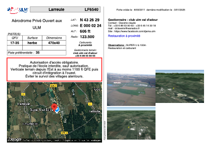
LF6540 - Larreule
Located in Larreule, France
ICAO - , IATA -
Data provided by AirmateGeneral information
Coordinates: N43°26'29" E0°2'24"
Elevation is 606 feet MSL.
View others Airports in Midi-Pyrénées
Operational data
Special qualification required
Current time UTC:
Current local time:
Weather at : LFBT - Tarbes Lourdes Pyrenees ( 29 km )
METAR: LFBT 170000Z AUTO 16003KT 9999 -RA FEW033 OVC041 04/04 Q1018 NOSIG
TAF: TAF LFBT 162300Z 1700/1724 VRB03KT 9999 SCT020 BKN040 PROB30 1703/1707 3000 BR TEMPO 1710/1717 07010KT
Communications frequencies: [VIEW]
Runways:
| RWY identifier | QFU | Length (ft) | Width (ft) | Surface | LDA (ft) |
| 17 | 0° | 1541 | 131 | GRASS | |
| 35 | 0° | 1541 | 131 | GRASS |
Airport contact information
Address: Larreule France
Satellite view of LF6540
Sorry, we have no imagery here.
Sorry, we have no imagery here.
Sorry, we have no imagery here.
Sorry, we have no imagery here.
Sorry, we have no imagery here.
Sorry, we have no imagery here.