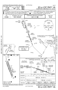
IAC chart of KXNA
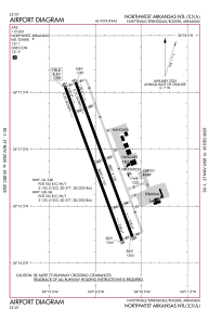
 ADC chart of KXNA
 Satellite view of KXNA
ADC chart of KXNA
Satellite view of KXNA
Sorry, we have no imagery here.
Sorry, we have no imagery here.
Sorry, we have no imagery here.
Sorry, we have no imagery here.
Sorry, we have no imagery here.
Sorry, we have no imagery here.


KXNA - Northwest Arkansas Ntl
Located in Fayetteville/Springdale/Rogers, United States
ICAO - XNA, IATA - XNA
Data provided by AirmateGeneral information
Coordinates: N36°16'54" W94°18'28"
Elevation is 1288 feet MSL.
Magnetic variation is 01° East View others Airports in Arkansas
Operational data
Special qualification required
Current time UTC:
Current local time:
Weather
METAR: KXNA 190753Z AUTO 13008KT 10SM CLR 18/16 A2974 RMK AO2 SLP061 T01780156
TAF: KXNA 190526Z 1906/2006 12011G20KT P6SM BKN050 TEMPO 1908/1912 BKN025 FM191400 17012G22KT P6SM VCSH BKN025 FM191900 17015G25KT P6SM -SHRA SCT025 BKN050 PROB30 1919/1924 2SM TSRA BKN025CB FM200000 16011G20KT 6SM -TSRA OVC015CB TEMPO 2002/2006 VRB20G35KT 1SM +TSRA OVC015CB
Communications frequencies: [VIEW]
Runways:
| RWY identifier | QFU | Length (ft) | Width (ft) | Surface | LDA (ft) |
| 16L | 160° | 8801 | 150 | CONC | 8800 |
| 34R | 340° | 8801 | 150 | CONC | 8800 |
| 16R | 160° | 8800 | 150 | CONC | 8800 |
| 34L | 340° | 8800 | 150 | CONC | 8800 |
Airport contact information
Address: Fayetteville/Springdale/Rogers United States
Satellite view of KXNA
Sorry, we have no imagery here.
Sorry, we have no imagery here.
Sorry, we have no imagery here.
Sorry, we have no imagery here.
Sorry, we have no imagery here.
Sorry, we have no imagery here.