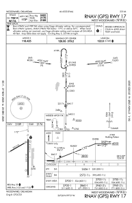
IAC chart of KWWR
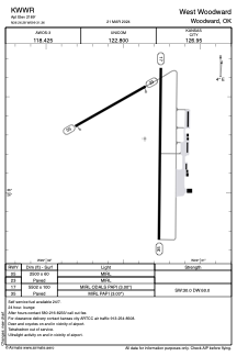
 ADC chart of KWWR
 Satellite view of KWWR
ADC chart of KWWR
Satellite view of KWWR
Sorry, we have no imagery here.
Sorry, we have no imagery here.
Sorry, we have no imagery here.
Sorry, we have no imagery here.
Sorry, we have no imagery here.
Sorry, we have no imagery here.


KWWR - West Woodward
Located in Woodward, United States
ICAO - WWR, IATA - WWR
Data provided by AirmateGeneral information
Coordinates: N36°26'17" W99°31'22"
Elevation is 2189 feet MSL.
Magnetic variation is 08° East View others Airports in Oklahoma
Operational data
Special qualification required
Current time UTC:
Current local time:
Weather
METAR: KWWR 130335Z AUTO 16024G31KT 10SM CLR 23/08 A2974 RMK AO2
TAF: KWWR 122320Z 1300/1324 19019G26KT P6SM SKC FM130300 19017G24KT P6SM SCT250 WS020/21055KT FM131100 27011KT P6SM SKC FM131800 35008KT P6SM SKC
Communications frequencies: [VIEW]
Runways:
| RWY identifier | QFU | Length (ft) | Width (ft) | Surface | LDA (ft) |
| 05 | 60° | 2500 | 60 | ASPH | |
| 23 | 240° | 2500 | 60 | ASPH | |
| 17 | 180° | 5502 | 100 | CONC | |
| 35 | 0° | 5502 | 100 | CONC |
Airport contact information
Address: Woodward United States
Satellite view of KWWR
Sorry, we have no imagery here.
Sorry, we have no imagery here.
Sorry, we have no imagery here.
Sorry, we have no imagery here.
Sorry, we have no imagery here.
Sorry, we have no imagery here.