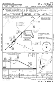
IAC chart of KWRI
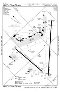
 ADC chart of KWRI
 Satellite view of KWRI

ADC chart of KWRI
Satellite view of KWRI
Sorry, we have no imagery here.
Sorry, we have no imagery here.
Sorry, we have no imagery here.
Sorry, we have no imagery here.
Sorry, we have no imagery here.
Sorry, we have no imagery here.


KWRI - Mc Guire Fld (Joint Base Mc Guire Dix Lakehurst)
Located in Wrightstown, United States
ICAO - WRI, IATA - WRI
Data provided by AirmateGeneral information
Coordinates: N40°0'56" W74°35'30"
Elevation is 140 feet MSL.
Magnetic variation is -12° East View others Airports in New Jersey
Operational data
Special qualification required
Current time UTC:
Current local time:
Weather
TAF: TAF KWRI 170200Z 1702/1808 20020G35KT 9000 -RA OVC015 QNH2975INS BECMG 1704/1705 21015G25KT 3200 RA OVC010 QNH2973INS BECMG 1708/1709 19010KT 4800 -RA BR OVC010 QNH2973INS BECMG 1712/1713 VRB06KT 8000 -SHRA BR OVC009 QNH2974INS BECMG 1715/1716 31010G15KT 9999 NSW OVC021 QNH2977INS BECMG 1719/1720 31012G20KT 9999 BKN040 OVC060 QNH2980INS TX15/1719Z TN12/1713Z
Communications frequencies: [VIEW]
Runways:
| RWY identifier | QFU | Length (ft) | Width (ft) | Surface | LDA (ft) |
| 06 | 45° | 10014 | 150 | OTHER | |
| 24 | 225° | 10014 | 150 | OTHER | |
| 18 | 173° | 7126 | 150 | CONC | |
| 36 | 353° | 7126 | 150 | CONC |
Airport contact information
Address: Wrightstown United States
Satellite view of KWRI
Sorry, we have no imagery here.
Sorry, we have no imagery here.
Sorry, we have no imagery here.
Sorry, we have no imagery here.
Sorry, we have no imagery here.
Sorry, we have no imagery here.