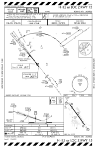
IAC chart of KWRB
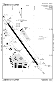
 ADC chart of KWRB
 Satellite view of KWRB

ADC chart of KWRB
Satellite view of KWRB
Sorry, we have no imagery here.
Sorry, we have no imagery here.
Sorry, we have no imagery here.
Sorry, we have no imagery here.
Sorry, we have no imagery here.
Sorry, we have no imagery here.


KWRB - Robins Afb
Located in Warner Robins, United States
ICAO - WRB, IATA - WRB
Data provided by AirmateGeneral information
Coordinates: N32°38'25" W83°35'31"
Elevation is 294 feet MSL.
Magnetic variation is -02° East View others Airports in Georgia
Operational data
Special qualification required
Current time UTC:
Current local time:
Weather
METAR: KWRB 170255Z AUTO 30014G19KT 10SM SCT110 18/05 A2985 RMK AO2 SLP109 T01840046 52023
TAF: TAF AMD KWRB 170155Z 1701/1806 25012KT 9999 SCT080 QNH2979INS TEMPO 1702/1705 31010G20KT BECMG 1714/1715 30010G20KT 9999 SKC QNH3011INS BECMG 1723/1724 30009KT 9999 SKC QNH3013INS TX17/1721Z TN06/1711Z
Communications frequencies: [VIEW]
Runways:
| RWY identifier | QFU | Length (ft) | Width (ft) | Surface | LDA (ft) |
| 15 | 144° | 12001 | 300 | OTHER | |
| 33 | 324° | 12001 | 300 | OTHER |
Airport contact information
Address: Warner Robins United States
Satellite view of KWRB
Sorry, we have no imagery here.
Sorry, we have no imagery here.
Sorry, we have no imagery here.
Sorry, we have no imagery here.
Sorry, we have no imagery here.
Sorry, we have no imagery here.