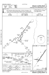
IAC chart of KVSF
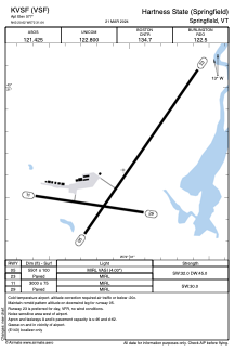
 ADC chart of KVSF
 Satellite view of KVSF
ADC chart of KVSF
Satellite view of KVSF
Sorry, we have no imagery here.
Sorry, we have no imagery here.
Sorry, we have no imagery here.
Sorry, we have no imagery here.
Sorry, we have no imagery here.
Sorry, we have no imagery here.


KVSF - Hartness State (Springfield)
Located in Springfield, United States
ICAO - VSF, IATA - VSF
Data provided by AirmateGeneral information
Coordinates: N43°20'37" W72°31'2"
Elevation is 577 feet MSL.
Magnetic variation is -15° East View others Airports in Vermont
Operational data
Special qualification required
Current time UTC:
Current local time:
Weather
METAR: KVSF 102254Z AUTO 13003KT 10SM FEW070 BKN090 OVC110 09/M07 A3023 RMK AO2 SLP244 T00891067
Communications frequencies: [VIEW]
Runways:
| RWY identifier | QFU | Length (ft) | Width (ft) | Surface | LDA (ft) |
| 05 | 35° | 5501 | 100 | ASPH | |
| 23 | 215° | 5501 | 100 | ASPH | |
| 11 | 99° | 3000 | 75 | ASPH | |
| 29 | 279° | 3000 | 75 | ASPH |
Airport contact information
Address: Springfield United States
Other aviation service providers
Flight schools

Satellite view of KVSF
Sorry, we have no imagery here.
Sorry, we have no imagery here.
Sorry, we have no imagery here.
Sorry, we have no imagery here.
Sorry, we have no imagery here.
Sorry, we have no imagery here.