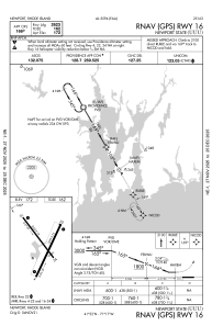
IAC chart of KUUU
 ADC chart of KUUU
 Satellite view of KUUU
ADC chart of KUUU
Satellite view of KUUU
Sorry, we have no imagery here.
Sorry, we have no imagery here.
Sorry, we have no imagery here.
Sorry, we have no imagery here.
Sorry, we have no imagery here.
Sorry, we have no imagery here.


KUUU - Newport State
Located in Newport, United States
ICAO - UUU, IATA - NPT
Data provided by AirmateGeneral information
Coordinates: N41°31'57" W71°16'54"
Elevation is 171 feet MSL.
Magnetic variation is -15° East View others Airports in Rhode Island
Operational data
Special qualification required
Current time UTC:
Current local time:
Weather
METAR: KUUU 222053Z AUTO 22009G23KT 190V260 10SM CLR 09/04 A2961 RMK AO2 PK WND 19027/2027 SLP028 T00940044 56018
Communications frequencies: [VIEW]
Runways:
| RWY identifier | QFU | Length (ft) | Width (ft) | Surface | LDA (ft) |
| 04 | 24° | 2999 | 75 | ASPH | |
| 22 | 204° | 2999 | 75 | ASPH | |
| 16 | 144° | 2623 | 75 | ASPH | |
| 34 | 324° | 2623 | 75 | ASPH |
Airport contact information
Address: Newport United States
Other aviation service providers
Flight schools

Satellite view of KUUU
Sorry, we have no imagery here.
Sorry, we have no imagery here.
Sorry, we have no imagery here.
Sorry, we have no imagery here.
Sorry, we have no imagery here.
Sorry, we have no imagery here.