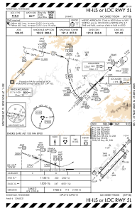
IAC chart of KTYS
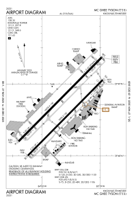
 ADC chart of KTYS
 Satellite view of KTYS

ADC chart of KTYS
Satellite view of KTYS
Sorry, we have no imagery here.
Sorry, we have no imagery here.
Sorry, we have no imagery here.
Sorry, we have no imagery here.
Sorry, we have no imagery here.
Sorry, we have no imagery here.


KTYS - Mc Ghee Tyson
Located in Knoxville, United States
ICAO - TYS, IATA - TYS
Data provided by AirmateGeneral information
Coordinates: N35°48'40" W83°59'39"
Elevation is 986 feet MSL.
Magnetic variation is -06° East View others Airports in Tennessee
Operational data
Special qualification required
Current time UTC:
Current local time:
Weather
METAR: KTYS 120853Z 26007KT 10SM CLR 11/M01 A2991 RMK AO2 SLP122 T01111006 56002
TAF: KTYS 120521Z 1206/1306 22005KT P6SM SKC FM121700 23010G18KT P6SM FEW250 FM130100 22005KT P6SM SCT250
Communications frequencies: [VIEW]
Runways:
| RWY identifier | QFU | Length (ft) | Width (ft) | Surface | LDA (ft) |
| 05L | 45° | 10000 | 150 | CONC | 9508 |
| 23R | 225° | 10000 | 150 | CONC | 9495 |
| 05R | 45° | 9000 | 150 | ASPH | 8600 |
| 23L | 225° | 9000 | 150 | ASPH | 8600 |
Airport contact information
Address: Knoxville United States
Satellite view of KTYS
Sorry, we have no imagery here.
Sorry, we have no imagery here.
Sorry, we have no imagery here.
Sorry, we have no imagery here.
Sorry, we have no imagery here.
Sorry, we have no imagery here.