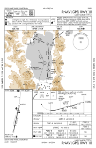
IAC chart of KTVL
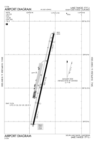
 ADC chart of KTVL
 Satellite view of KTVL
ADC chart of KTVL
Satellite view of KTVL
Sorry, we have no imagery here.
Sorry, we have no imagery here.
Sorry, we have no imagery here.
Sorry, we have no imagery here.
Sorry, we have no imagery here.
Sorry, we have no imagery here.


KTVL - Lake Tahoe
Located in South Lake Tahoe, United States
ICAO - TVL, IATA - TVL
Data provided by AirmateGeneral information
Coordinates: N38°53'38" W119°59'43"
Elevation is 6268 feet MSL.
Magnetic variation is 16° East View others Airports in California
Operational data
Special qualification required
Current time UTC:
Current local time:
Weather
METAR: KTVL 250353Z AUTO 00000KT 10SM CLR 06/02 A3031 RMK AO2 SLP253 T00560022
TAF: KTVL 242320Z 2500/2524 VRB04KT P6SM SKC FM252000 02006KT P6SM SKC FM252200 17007KT P6SM FEW250
Communications frequencies: [VIEW]
Runways:
| RWY identifier | QFU | Length (ft) | Width (ft) | Surface | LDA (ft) |
| 18 | 193° | 8541 | 100 | ASPH | 7017 |
| 36 | 13° | 8541 | 100 | ASPH | 5708 |
Airport contact information
Address: South Lake Tahoe United States
Other aviation service providers
Flight schools

Satellite view of KTVL
Sorry, we have no imagery here.
Sorry, we have no imagery here.
Sorry, we have no imagery here.
Sorry, we have no imagery here.
Sorry, we have no imagery here.
Sorry, we have no imagery here.