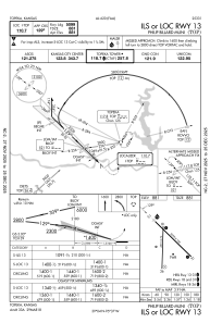
IAC chart of KTOP
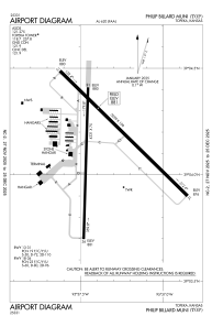
 ADC chart of KTOP
 Satellite view of KTOP

ADC chart of KTOP
Satellite view of KTOP
Sorry, we have no imagery here.
Sorry, we have no imagery here.
Sorry, we have no imagery here.
Sorry, we have no imagery here.
Sorry, we have no imagery here.
Sorry, we have no imagery here.


KTOP - Philip Billard Muni
Located in Topeka, United States
ICAO - TOP, IATA -
Data provided by AirmateGeneral information
Coordinates: N39°4'8" W95°37'21"
Elevation is 881 feet MSL.
Magnetic variation is 05° East View others Airports in Kansas
Operational data
Special qualification required
Current time UTC:
Current local time:
Weather
METAR: KTOP 172353Z 18010KT 10SM CLR 24/M01 A2978 RMK AO2 SLP081 T02391006 10261 20211 56010
TAF: KTOP 172320Z 1800/1824 16007KT P6SM FEW200 FM180500 17010KT P6SM SCT200 WS012/20040KT FM181200 20016G28KT P6SM SCT200
Communications frequencies: [VIEW]
Runways:
| RWY identifier | QFU | Length (ft) | Width (ft) | Surface | LDA (ft) |
| 13 | 134° | 5099 | 100 | ASPH | |
| 31 | 314° | 5099 | 100 | ASPH | |
| 18 | 182° | 4331 | 75 | ASPH | |
| 36 | 2° | 4331 | 75 | ASPH |
Airport contact information
Address: Topeka United States
Other aviation service providers
Flight schools

Satellite view of KTOP
Sorry, we have no imagery here.
Sorry, we have no imagery here.
Sorry, we have no imagery here.
Sorry, we have no imagery here.
Sorry, we have no imagery here.
Sorry, we have no imagery here.