IAC chart of KTOL
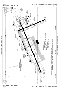
 ADC chart of KTOL
 Satellite view of KTOL
ADC chart of KTOL
Satellite view of KTOL
Sorry, we have no imagery here.
Sorry, we have no imagery here.
Sorry, we have no imagery here.
Sorry, we have no imagery here.
Sorry, we have no imagery here.
Sorry, we have no imagery here.


KTOL - Eugene F Kranz Toledo Express
Located in Toledo, United States
ICAO - TOL, IATA - TOL
Data provided by AirmateGeneral information
Coordinates: N41°35'13" W83°48'28"
Elevation is 683 feet MSL.
Magnetic variation is -05° East View others Airports in Ohio
Operational data
Special qualification required
Current time UTC:
Current local time:
Weather
METAR: KTOL 170752Z 31005KT 10SM CLR M01/M05 A3007 RMK AO2 SLP188 T10111050 $
TAF: KTOL 170537Z 1706/1806 31009KT P6SM SCT025 FM171100 19007KT P6SM SCT250
Communications frequencies: [VIEW]
Runways:
| RWY identifier | QFU | Length (ft) | Width (ft) | Surface | LDA (ft) |
| 07 | 67° | 10600 | 150 | ASPH | 10599 |
| 25 | 247° | 10600 | 150 | ASPH | 10599 |
| 16 | 157° | 5599 | 150 | ASPH | 5599 |
| 34 | 337° | 5599 | 150 | ASPH | 5599 |
Airport contact information
Address: Toledo United States
Other aviation service providers
Flight schools

Satellite view of KTOL
Sorry, we have no imagery here.
Sorry, we have no imagery here.
Sorry, we have no imagery here.
Sorry, we have no imagery here.
Sorry, we have no imagery here.
Sorry, we have no imagery here.