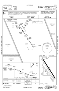
IAC chart of KTLR
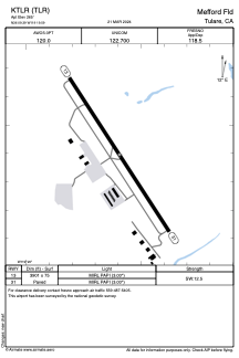
 ADC chart of KTLR
 Satellite view of KTLR
ADC chart of KTLR
Satellite view of KTLR
Sorry, we have no imagery here.
Sorry, we have no imagery here.
Sorry, we have no imagery here.
Sorry, we have no imagery here.
Sorry, we have no imagery here.
Sorry, we have no imagery here.


KTLR - Mefford Fld
Located in Tulare, United States
ICAO - TLR, IATA -
Data provided by AirmateGeneral information
Coordinates: N36°9'24" W119°19'36"
Elevation is 265 feet MSL.
Magnetic variation is 12° East View others Airports in California
Operational data
Special qualification required
Current time UTC:
Current local time:
Weather at : KVIS - Visalia Muni ( 19 km )
METAR: KVIS 191156Z AUTO 00000KT 10SM CLR 12/07 A3001 RMK AO2 SLP159 T01220072 10194 20122 53004 $
TAF: KVIS 191120Z 1912/2012 VRB06KT P6SM SKC FM191800 26007KT P6SM SKC FM192100 31013G21KT P6SM SKC FM200300 30007KT P6SM SKC
Communications frequencies: [VIEW]
Runways:
| RWY identifier | QFU | Length (ft) | Width (ft) | Surface | LDA (ft) |
| 13 | 147° | 3901 | 75 | ASPH | |
| 31 | 327° | 3901 | 75 | ASPH |
Airport contact information
Address: Tulare United States
Satellite view of KTLR
Sorry, we have no imagery here.
Sorry, we have no imagery here.
Sorry, we have no imagery here.
Sorry, we have no imagery here.
Sorry, we have no imagery here.
Sorry, we have no imagery here.