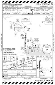
IAC chart of KTLH
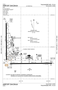
 ADC chart of KTLH
 Satellite view of KTLH

ADC chart of KTLH
Satellite view of KTLH
Sorry, we have no imagery here.
Sorry, we have no imagery here.
Sorry, we have no imagery here.
Sorry, we have no imagery here.
Sorry, we have no imagery here.
Sorry, we have no imagery here.


KTLH - Tallahassee Intl
Located in Tallahassee, United States
ICAO - TLH, IATA - TLH
Data provided by AirmateGeneral information
Coordinates: N30°23'48" W84°21'3"
Elevation is 83 feet MSL.
Magnetic variation is -05° East View others Airports in Florida
Operational data
Special qualification required
Current time UTC:
Current local time:
Weather
METAR: KTLH 061253Z 30012G18KT 10SM CLR 09/M02 A2999 RMK AO2 SLP155 T00941022
TAF: KTLH 061120Z 0612/0712 30013G22KT P6SM SKC FM062000 31011KT P6SM SKC FM070000 30005KT P6SM SKC
Communications frequencies: [VIEW]
Runways:
| RWY identifier | QFU | Length (ft) | Width (ft) | Surface | LDA (ft) |
| 09 | 89° | 8000 | 150 | ASPH | |
| 27 | 269° | 8000 | 150 | ASPH | |
| 18 | 179° | 7000 | 150 | ASPH | |
| 36 | 359° | 7000 | 150 | ASPH |
Airport contact information
Address: Tallahassee United States
Other aviation service providers
Flight schools

Satellite view of KTLH
Sorry, we have no imagery here.
Sorry, we have no imagery here.
Sorry, we have no imagery here.
Sorry, we have no imagery here.
Sorry, we have no imagery here.
Sorry, we have no imagery here.