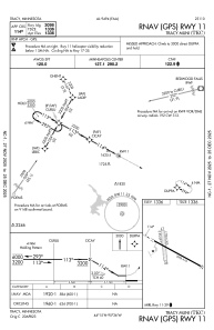
IAC chart of KTKC
 Satellite view of KTKC
Satellite view of KTKC
Sorry, we have no imagery here.
Sorry, we have no imagery here.
Sorry, we have no imagery here.
Sorry, we have no imagery here.
Sorry, we have no imagery here.
Sorry, we have no imagery here.


KTKC - Tracy Muni
Located in Tracy, United States
ICAO - TKC, IATA -
Data provided by AirmateGeneral information
Coordinates: N44°14'57" W95°36'26"
Elevation is 1335 feet MSL.
Magnetic variation is 05° East View others Airports in Minnesota
Operational data
Special qualification required
Current time UTC:
Current local time:
Weather
METAR: KTKC 190515Z AUTO 09015G21KT 10SM CLR 09/04 A2993 RMK AO2
Communications frequencies: [VIEW]
Runways:
| RWY identifier | QFU | Length (ft) | Width (ft) | Surface | LDA (ft) |
| 11 | 118° | 3098 | 75 | ASPH | |
| 29 | 298° | 3098 | 75 | ASPH | |
| 17 | 174° | 1778 | 200 | GRASS | |
| 35 | 354° | 1778 | 200 | GRASS |
Airport contact information
Address: Tracy United States
Satellite view of KTKC
Sorry, we have no imagery here.
Sorry, we have no imagery here.
Sorry, we have no imagery here.
Sorry, we have no imagery here.
Sorry, we have no imagery here.
Sorry, we have no imagery here.