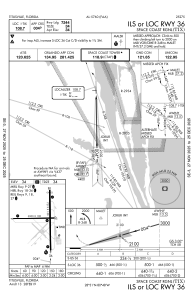
IAC chart of KTIX
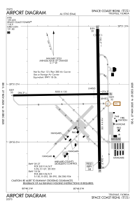
 ADC chart of KTIX
 Satellite view of KTIX
ADC chart of KTIX
Satellite view of KTIX
Sorry, we have no imagery here.
Sorry, we have no imagery here.
Sorry, we have no imagery here.
Sorry, we have no imagery here.
Sorry, we have no imagery here.
Sorry, we have no imagery here.


KTIX - Space Coast Rgnl
Located in Titusville, United States
ICAO - TIX, IATA -
Data provided by AirmateGeneral information
Coordinates: N28°30'53" W80°47'57"
Elevation is 33 feet MSL.
Magnetic variation is -05° East View others Airports in Florida
Operational data
Special qualification required
Current time UTC:
Current local time:
Weather
METAR: KTIX 181147Z 00000KT 7SM SKC 26/22 A3003
TAF: KTIX 181123Z 1812/1912 16008KT P6SM FEW015 SCT300 FM181700 10008KT P6SM FEW040 BKN300 FM190000 15007KT P6SM FEW045 BKN300
Communications frequencies: [VIEW]
Runways:
| RWY identifier | QFU | Length (ft) | Width (ft) | Surface | LDA (ft) |
| 09 | 89° | 5000 | 100 | ASPH | 5000 |
| 27 | 269° | 5000 | 100 | ASPH | 5000 |
| 18 | 179° | 7319 | 150 | ASPH | 6930 |
| 36 | 359° | 7319 | 150 | ASPH | 7244 |
Airport contact information
Address: Titusville United States
Other aviation service providers
Flight schools

Satellite view of KTIX
Sorry, we have no imagery here.
Sorry, we have no imagery here.
Sorry, we have no imagery here.
Sorry, we have no imagery here.
Sorry, we have no imagery here.
Sorry, we have no imagery here.