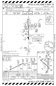
IAC chart of KTIK
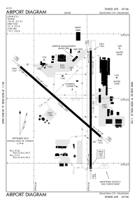
 ADC chart of KTIK
 Satellite view of KTIK
ADC chart of KTIK
Satellite view of KTIK
Sorry, we have no imagery here.
Sorry, we have no imagery here.
Sorry, we have no imagery here.
Sorry, we have no imagery here.
Sorry, we have no imagery here.
Sorry, we have no imagery here.


KTIK - Tinker Afb
Located in Oklahoma City, United States
ICAO - TIK, IATA -
Data provided by AirmateGeneral information
Coordinates: N35°24'53" W97°23'12"
Elevation is 1290 feet MSL.
Magnetic variation is 03° East View others Airports in Oklahoma
Operational data
Special qualification required
Current time UTC:
Current local time:
Weather
METAR: KTIK 290755Z AUTO 19012KT 10SM OVC010 16/14 A2969 RMK AO2 SLP048 T01640144
TAF: TAF KTIK 290100Z 2901/3007 17012G18KT 9999 SCT025 BKN035 QNH2975INS BECMG 2903/2904 16012KT 9999 BKN015 QNH2978INS BECMG 2905/2906 16012KT 8000 BR OVC008 QNH2980INS BECMG 2914/2915 17012G18KT 9999 NSW BKN015 QNH2972INS BECMG 2920/2921 18012G20KT 9999 SCT030 QNH2970INS BECMG 3000/3001 18009KT 9999 FEW150 QNH2961INS TX29/2921Z TN14/2910Z
Communications frequencies: [VIEW]
Runways:
| RWY identifier | QFU | Length (ft) | Width (ft) | Surface | LDA (ft) |
| 13 | 131° | 10000 | 200 | OTHER | |
| 31 | 311° | 10000 | 200 | OTHER | |
| 18 | 180° | 11100 | 200 | OTHER | |
| 36 | 360° | 11100 | 200 | OTHER |
Airport contact information
Address: Oklahoma City United States
Satellite view of KTIK
Sorry, we have no imagery here.
Sorry, we have no imagery here.
Sorry, we have no imagery here.
Sorry, we have no imagery here.
Sorry, we have no imagery here.
Sorry, we have no imagery here.