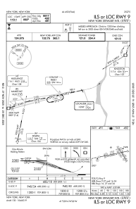
IAC chart of KSWF
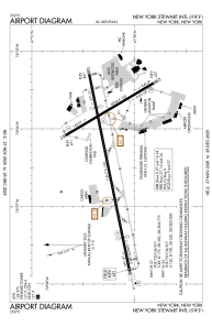
 ADC chart of KSWF
 Satellite view of KSWF
ADC chart of KSWF
Satellite view of KSWF
Sorry, we have no imagery here.
Sorry, we have no imagery here.
Sorry, we have no imagery here.
Sorry, we have no imagery here.
Sorry, we have no imagery here.
Sorry, we have no imagery here.


KSWF - New York Stewart Intl
Located in New York, United States
ICAO - SWF, IATA - SWF
Data provided by AirmateGeneral information
Coordinates: N41°30'15" W74°6'17"
Elevation is 490 feet MSL.
Magnetic variation is -14° East View others Airports in New York
Operational data
Special qualification required
Current time UTC:
Current local time:
Weather
METAR: KSWF 312145Z 20007KT 10SM SCT040 BKN050 22/15 A2956
TAF: KSWF 311935Z 3120/0124 23012G21KT 6SM -SHRA BR SCT020 BKN035 TEMPO 3121/3123 3SM -TSRA BR BKN020CB FM312300 22010KT 3SM SHRA OVC025 TEMPO 3123/0103 27025G40KT 2SM TSRA BR OVC015CB FM010300 32010G19KT 5SM -SHRA BR BKN015 OVC050 FM010600 34012G22KT P6SM OVC024 PROB30 0106/0109 4SM -SHRA BR OVC025 FM011200 32018G27KT P6SM SKC AMD NOT SKED
Communications frequencies: [VIEW]
Runways:
| RWY identifier | QFU | Length (ft) | Width (ft) | Surface | LDA (ft) |
| 09 | 78° | 11817 | 150 | ASPH | 8817 |
| 27 | 258° | 11817 | 150 | ASPH | 9817 |
| 16 | 149° | 6004 | 150 | ASPH | 6004 |
| 34 | 329° | 6004 | 150 | ASPH | 6004 |
| H1 | 0° | 0 | 0 | UNK |
Airport contact information
Address: New York United States
Other aviation service providers
Flight schools

Independent Helicopters, Llc
Independent Helicopters, Llc
independenthelicopters@gmail.com+1(845)549-3755
Satellite view of KSWF
Sorry, we have no imagery here.
Sorry, we have no imagery here.
Sorry, we have no imagery here.
Sorry, we have no imagery here.
Sorry, we have no imagery here.
Sorry, we have no imagery here.