IAC chart of KSUX
 ADC chart of KSUX
 Satellite view of KSUX

ADC chart of KSUX
Satellite view of KSUX
Sorry, we have no imagery here.
Sorry, we have no imagery here.
Sorry, we have no imagery here.
Sorry, we have no imagery here.
Sorry, we have no imagery here.
Sorry, we have no imagery here.


KSUX - Sioux Gateway/Brig General Bud Day Fld
Located in Sioux City, United States
ICAO - SUX, IATA - SUX
Data provided by AirmateGeneral information
Coordinates: N42°24'5" W96°23'4"
Elevation is 1098 feet MSL.
Magnetic variation is 03° East View others Airports in Iowa
Operational data
Special qualification required
Current time UTC:
Current local time:
Weather
METAR: KSUX 162352Z 18012KT 10SM CLR 10/M07 A2990 RMK AO2 SLP136 T01001072 10117 20039 56010
TAF: KSUX 162320Z 1700/1724 17010KT P6SM FEW250 FM170500 16012G19KT P6SM BKN150 WS010/21040KT FM171400 19011G18KT P6SM FEW250 WS020/25035KT FM171500 22012G20KT P6SM FEW250 FM171800 25013G21KT P6SM SCT250 FM172200 27009KT P6SM FEW250
Communications frequencies: [VIEW]
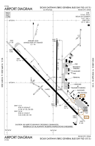
Runways:
| RWY identifier | QFU | Length (ft) | Width (ft) | Surface | LDA (ft) |
| 13 | 136° | 9002 | 150 | CONC | 9002 |
| 31 | 316° | 9002 | 150 | CONC | 9002 |
| 18 | 181° | 6401 | 100 | ASPH | 6400 |
| 36 | 1° | 6401 | 100 | ASPH | 6400 |
Airport contact information
Address: Sioux City United States
Satellite view of KSUX
Sorry, we have no imagery here.
Sorry, we have no imagery here.
Sorry, we have no imagery here.
Sorry, we have no imagery here.
Sorry, we have no imagery here.
Sorry, we have no imagery here.