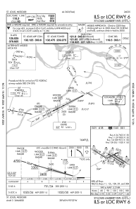
IAC chart of KSTL
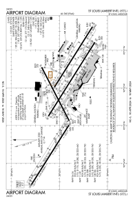
 ADC chart of KSTL
 Satellite view of KSTL
ADC chart of KSTL
Satellite view of KSTL
Sorry, we have no imagery here.
Sorry, we have no imagery here.
Sorry, we have no imagery here.
Sorry, we have no imagery here.
Sorry, we have no imagery here.
Sorry, we have no imagery here.


KSTL - St Louis Lambert Intl
Located in St Louis, United States
ICAO - STL, IATA - STL
Data provided by AirmateGeneral information
Coordinates: N38°44'55" W90°22'12"
Elevation is 617 feet MSL.
Magnetic variation is -01° East View others Airports in Missouri
Operational data
Special qualification required
Current time UTC:
Current local time:
Weather
METAR: KSTL 221451Z 30008KT 10SM CLR 09/M02 A3012 RMK AO2 SLP197 T00941022 51033 $
TAF: KSTL 221505Z 2215/2318 31009KT P6SM FEW250 FM222100 VRB04KT P6SM SCT250 FM230000 12008KT P6SM OVC150 FM230800 13012G20KT 5SM -TSRA OVC040CB TEMPO 2308/2312 3SM TSRA OVC025CB FM231200 16012G20KT 6SM -TSRA OVC020CB
Communications frequencies: [VIEW]
Runways:
| RWY identifier | QFU | Length (ft) | Width (ft) | Surface | LDA (ft) |
| 06 | 63° | 7603 | 150 | CONC | 7323 |
| 24 | 243° | 7603 | 150 | CONC | 7603 |
| 11 | 122° | 9000 | 150 | CONC | 9000 |
| 29 | 302° | 9000 | 150 | CONC | 9000 |
| 12L | 122° | 9013 | 150 | CONC | 8956 |
| 30R | 302° | 9013 | 150 | CONC | 9013 |
| 12R | 122° | 11020 | 150 | CONC | 10553 |
| 30L | 302° | 11020 | 150 | CONC | 10679 |
Airport contact information
Address: St Louis United States
Other aviation service providers
Flight schools

Satellite view of KSTL
Sorry, we have no imagery here.
Sorry, we have no imagery here.
Sorry, we have no imagery here.
Sorry, we have no imagery here.
Sorry, we have no imagery here.
Sorry, we have no imagery here.