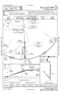
IAC chart of KSTJ
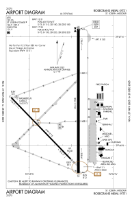
 ADC chart of KSTJ
 Satellite view of KSTJ
ADC chart of KSTJ
Satellite view of KSTJ
Sorry, we have no imagery here.
Sorry, we have no imagery here.
Sorry, we have no imagery here.
Sorry, we have no imagery here.
Sorry, we have no imagery here.
Sorry, we have no imagery here.


KSTJ - Rosecrans Meml
Located in St Joseph, United States
ICAO - STJ, IATA -
Data provided by AirmateGeneral information
Coordinates: N39°46'19" W94°54'35"
Elevation is 826 feet MSL.
Magnetic variation is 04° East View others Airports in Missouri
Operational data
Special qualification required
Current time UTC:
Current local time:
Weather
METAR: KSTJ 231753Z 00000KT 10SM CLR 18/07 A3016 RMK AO2 SLP211 T01830067 10189 20089 58002
TAF: KSTJ 231727Z 2318/2418 VRB05KT P6SM BKN050 BKN100 TEMPO 2318/2321 6SM -SHRA FM232200 10007KT 5SM -TSRA BKN045CB FM240200 09007KT 6SM -SHRA BKN040 FM240500 06006KT P6SM BKN050 PROB30 2412/2416 5SM -TSRA BKN020CB
Communications frequencies: [VIEW]
Runways:
| RWY identifier | QFU | Length (ft) | Width (ft) | Surface | LDA (ft) |
| 13 | 136° | 4797 | 75 | CONC | 4797 |
| 31 | 316° | 4797 | 75 | CONC | 4797 |
| 17 | 180° | 8061 | 150 | CONC | 8061 |
| 35 | 0° | 8061 | 150 | CONC | 8061 |
Airport contact information
Address: St Joseph United States
Satellite view of KSTJ
Sorry, we have no imagery here.
Sorry, we have no imagery here.
Sorry, we have no imagery here.
Sorry, we have no imagery here.
Sorry, we have no imagery here.
Sorry, we have no imagery here.