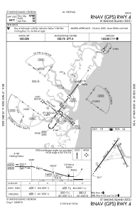
IAC chart of KSSI
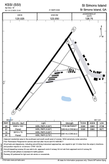
 ADC chart of KSSI
 Satellite view of KSSI
ADC chart of KSSI
Satellite view of KSSI
Sorry, we have no imagery here.
Sorry, we have no imagery here.
Sorry, we have no imagery here.
Sorry, we have no imagery here.
Sorry, we have no imagery here.
Sorry, we have no imagery here.


KSSI - St Simons Island
Located in St Simons Island, United States
ICAO - SSI, IATA -
Data provided by AirmateGeneral information
Coordinates: N31°9'7" W81°23'28"
Elevation is 18 feet MSL.
Magnetic variation is -05° East View others Airports in Georgia
Operational data
Special qualification required
Current time UTC:
Current local time:
Weather
METAR: KSSI 191635Z AUTO 11009KT 10SM CLR 30/24 A2997 RMK AO2
TAF: KSSI 191120Z 1912/2012 31003KT P6SM SCT030 BKN250 FM191300 28006KT P6SM SCT025 BKN250 FM191730 12009KT P6SM FEW035 BKN250 FM200100 18006KT P6SM FEW150 SCT250
Communications frequencies: [VIEW]
Runways:
| RWY identifier | QFU | Length (ft) | Width (ft) | Surface | LDA (ft) |
| 04 | 36° | 5584 | 100 | ASPH | 4798 |
| 22 | 216° | 5584 | 100 | ASPH | 4671 |
| 16 | 154° | 3313 | 75 | ASPH | |
| 34 | 334° | 3313 | 75 | ASPH |
Airport contact information
Address: St Simons Island United States
Satellite view of KSSI
Sorry, we have no imagery here.
Sorry, we have no imagery here.
Sorry, we have no imagery here.
Sorry, we have no imagery here.
Sorry, we have no imagery here.
Sorry, we have no imagery here.